Jump to: |
||
 |
 |
 |
|
1958 was a wet summer across the UK (and was indeed the third wet summer in a row), and September continued the wet sequence over England and Wales, but then a sequence of drier months followed. During 1959 the months of February, May, August and September were particularly dry, and the summer and autumn were broadly warmer and sunnier than average; only from November onwards did rainfall amounts recover. |
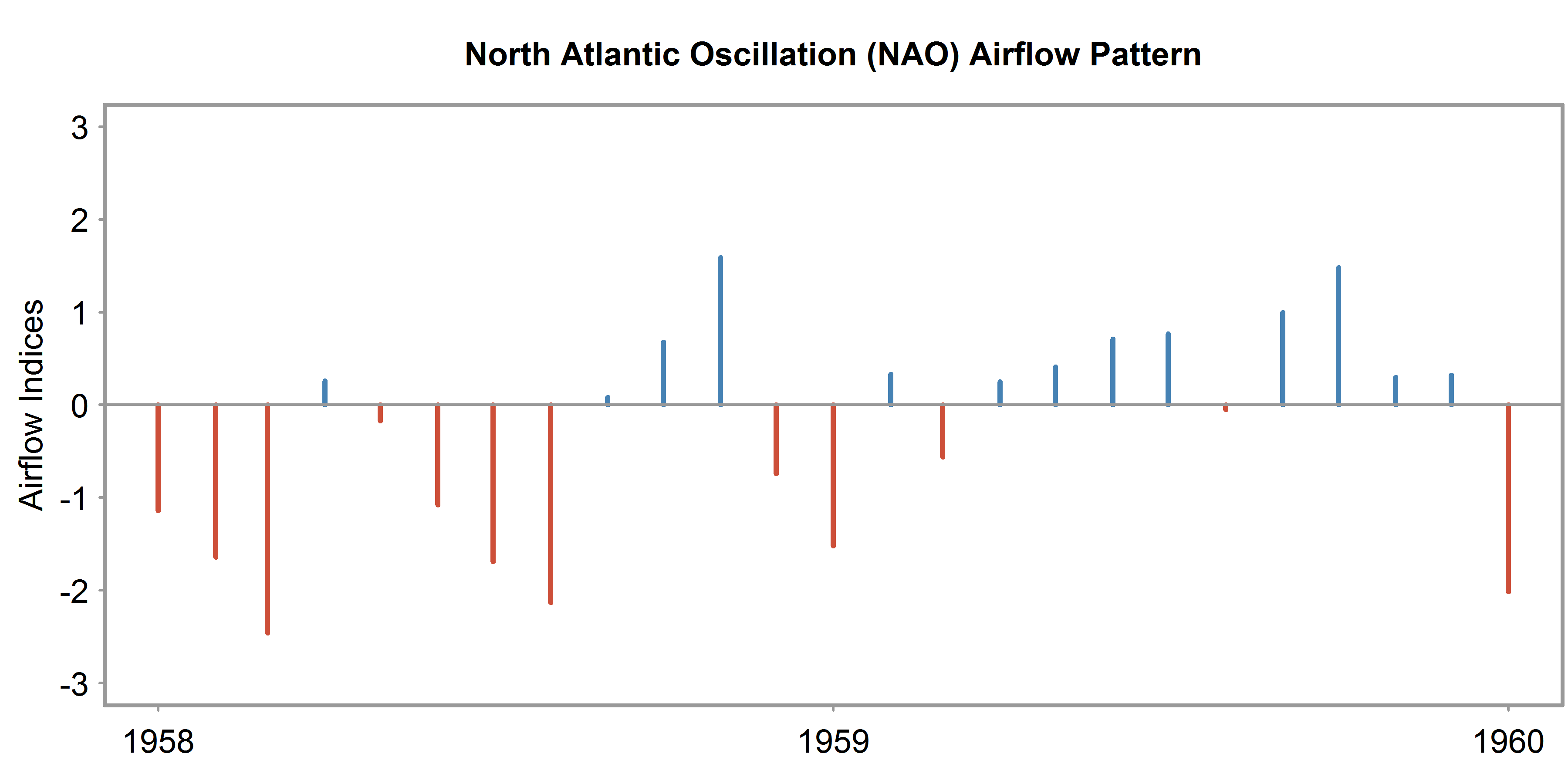
The plot below shows the monthly North Atlantic Oscillation (NAO) Index for the periods before, during and after the drought. The NAO is a prominent teleconnection pattern in all seasons, and strong positive phases tend to be associationed with above-average temperatures in northern Europe, whilst negative phases of the NAO tend to be associated with below-average temperatures. There is more information available here.


|
This short event began in the north-west of the UK in November 1958, where it quickly spread east to cover most parts of Scotland, northern England and Northern Ireland by the spring of 1959. Throughout summer, the drought affected area extended southwards, with the west coast seeing some temporary relief. Deficits returned to the west later in the summer with the drought reaching its maximum extent in August, September and October 1959. The severity of this event was most extreme during this period over eastern parts of the UK, as well as central England. This event terminated quickly with the winter recharge season, and by January 1960 deficits were eradicated in all but Anglian region where many catchments respond more slowly to rainfall. Despite being a single year event, the 1959 drought ranks within the top 10 droughts from 1891-2015 (though generally not within the top 5) for duration over a three month accumulation period for many catchments in the north. The maximum intensity of the event over a three month accumulation period ranked highly in several catchments of eastern Scotland, north-east England, Anglian and Severn-Trent regions, indicating that it was a short, but sharp, event in these catchments. The mean deficit was also notable in some of these eastern catchments. Over a twelve month accumulation period, this event envelops some of the deficits that continued particularly in Scotland and Northern Ireland from low flows seen in 1956. As such, over the longer accumulation period, the duration of the event was ranked within the top three for several catchments in Scotland. The maximum intensities are also ranked more highly (with most catchments placing this event among the top 5) across the north and east over a 12 month accumulation period. |
|
The 1959 meteorological drought did not express itself in unusually low groundwater levels in the observed records suggesting that it was too brief or insubstantial to produce a groundwater drought. There is no evidence for a groundwater drought in this period in the reconstructed groundwater level hydrographs, however, there is a degree of uncertainty in the reconstructions and minor groundwater droughts may be difficult to discern in the early reconstructed record. |