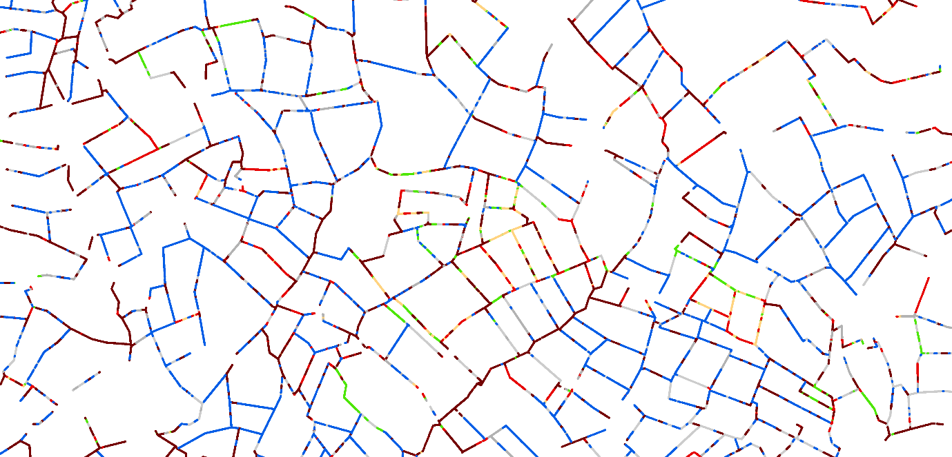
UKCEH’s Land Cover Plus: Hedgerows describes the extent and height of woody linear features, including hedgerows, tree lines and semi-natural thickets of shrubs and trees, on field boundaries in England. We have used the Environment Agency’s LIDAR (Light Detection and Ranging) remote sensing product, captured in 2016-2021, to create a model of woody field boundaries classified by height.
The data open up opportunities for quantifying, monitoring and assessing hedgerows for the whole of England, which is not reliant on labour-intensive fieldwork.
Land Cover Plus: Hedgerows data integrates spatially with UKCEH’s Land Cover Map and is also compatible with the height classes used in the Countryside Survey. The dataset is a representation of the presence and height of hedgerows along the boundaries of Land Cover Map polygons rather than a fully georeferenced map of the position of each hedgerow on the ground, although there is generally close agreement between the two.
UKCEH has previously created the Woody Linear Features Framework dataset describing the location and lengths of hedges and lines of trees for the whole of Great Britain. However, the opportunities presented by the National LIDAR Programme have allowed us to create a more accurate and detailed dataset for England incorporating the all-important attribute of shrub and tree heights.
Accuracy
The model was validated by ‘ground-truthing’ against hedgerow and tree-line features in 38 test squares of 1 km2 each, which were surveyed on the ground by trained fieldworkers in 2022 using Countryside Survey methods.
The results showed good agreement between the LIDAR model and the ground-truthing, allowing for a spatial buffer tolerance around features to account for the different linear frameworks they were based upon. At the summary scale across all test squares, the total woody feature lengths showed a 96% agreement. At the scale of individual test squares, there was an average 76% agreement of woody feature lengths within a 20m buffer tolerance. Height classifications of the model showed an exact agreement for 32% of the total feature lengths, and 63% agreement within a tolerance of one class above or below.
Technical features
Format: Vector
Scale: Each minimum 2m long segment of hedgerow or woody linear feature is classified, from a minimum height of 0.5m to the feature maximum; based on original 1cm vertical resolution and 1m horizontal resolution, summarised into 0.5m, 1m or 2m height bands to a maximum band of 6+ m tall.
Units: Length and height in metres (summarised into seven height classes) attributed with feature type (eg. double hedge, single hedge)
Supply Format: Geopackage format as 5,881 individual tiles of 10 m size, totalling 9.51GB.
Coverage: England (but excludes areas classified in the UKCEH Land Cover Map as woodland, urban/suburban, coastal, open water, mountain/moor/heath).
Period: Derived from processing of the Environment Agency LIDAR product (National LIDAR Programme), captured in 2016-2021.
Spatial Reference System: British National Grid / Ordnance Survey Grid
Potential uses
- Quantify the amount of woody field boundaries, and their type (by height class) for management, planning or mitigation.
- Map the extent and distribution of wildlife habitats and dispersal corridors.
- Aid planning in identifying where to create more hedges as corridors to better link up the hedgerow network and other habitats, such as woodland.
- Estimate potential carbon storage in hedgerows and woody field boundaries.
- Aid catchment flood modelling by representing landscape barriers and roughness.
- Provide a clear baseline for future monitoring of hedgerow/field boundary features on a local or national scale. Repetition every 10 to 20 years would give a good picture of national changes and whether targets for planting and management were being met.
Obtaining a licence
Please contact the UKCEH Data Licensing Team using our Data Request Form or emailing Spatial Data for more information.
The way we license our Land Cover Plus: Hedgerows dataset depends upon its intended use.
For non-commercial use, such as by charities, government and non-profit organisations as well as their contractors, Land Cover Plus: Hedgerows is available under licence. While data fees will not be charged, administration fees (total of £300 plus VAT) will apply. A condition of the licence is that information on how the dataset is used is provided annually to help inform its development. See dataset and citation information.
Land Cover Plus: Hedgerows is available for commercial internal business use under licence and subject to payment of an annual licence fee.
For academic research and education, Land Cover plus: Hedgerows will be available for free to subscribers of the EDINA Environment Digimap Service, which include all staff and students at more than 160 UK educational establishments. Until then, (or if your academic institution does not subscribe to EDINA) please contact the UKCEH Data Licensing Team. We will arrange for you to access the data under licence for an administration fee of £300 plus VAT.