Note: UKCEH’s Woody Linear Features Framework dataset has been superseded for England only by Land Cover Plus: Hedgerows. Opportunities presented by the National LIDAR Programme have allowed us to create this more accurate and detailed dataset for England incorporating the all-important attribute of shrub and tree heights.
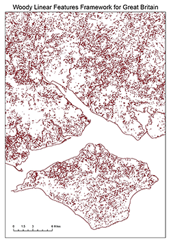
Our Woody Linear Features Framework describes the location and lengths of hedge boundaries and lines of trees (woody linear features) across the whole of Great Britain. The dataset was derived from existing national datasets and created by a predictive model, which was developed at the Centre for Ecology & Hydrology in 2016. This unique dataset shows hedges/lines of trees on all land in Britain, not just agricultural. These features are Priority Habitats in their own right and are extremely valuable, particularly in intensively managed landscapes.
Technical features
Format: Vector
Scale: 1:5,000
Supply Format: ESRI® Shapefile format
Coverage: Great Britain
Spatial Reference System: OSGB 1936 / British National Grid
Publications
Scholefield, P., Morton, D, Rowland, C, Henrys, P, Howard, D and Norton, L (2016). A model of the extent and distribution of woody linear features in rural Great Britain. Ecology and Evolution, 6: 8893–8902. doi: 10.1002/ece3.2607
Scholefield, P A; Morton, R D; Rowland, C S; Henrys, P A; Howard, D C; Norton, L R. (2016). Woody linear features framework, Great Britain v.1.0. NERC Environmental Information Data Centre. https://doi.org/10.5285/d7da6cb9-104b-4dbc-b709-c1f7ba94fb16
Related links
- Further information and online ordering is available from the Environmental Information Data Centre
-
DocumentGB Woody Linear Features Framework v1.0.pdf PDF - 377.45 KB
Obtaining a licence
Bespoke licensing terms and/or fees apply to this dataset. To obtain a licence, please contact the UKCEH Data Licensing Team by email or via our data request form:
Email: spatialdata@ceh.ac.uk
Please fill in our form to request map data
Academic research and education
Woody Linear Features Framework data are available for free for users of the EDINA Environment Digimap service, which includes staff and students at more than a hundred UK further and higher education establishments.