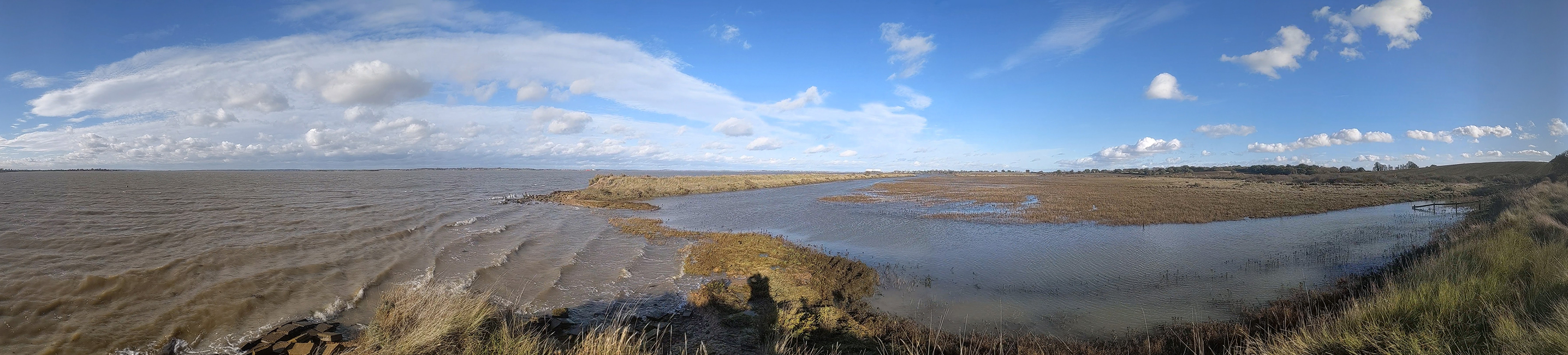
Saltmarshes can help tackle climate change by sequestering atmospheric carbon in situ through plant growth and storing it, along with carbon imported by creeks and tides via connections with other habitats, over extended timescales.
UKCEH works on multiple projects to gather key evidence needed for potentially reporting greenhouse gas (GHG) emissions and removals from managed ‘blue carbon’ habitats, such as saltmarsh, in the Land Use, Land Use Change and Forestry (LULUCF) sector of the UK GHG Inventory.
This research is essential for ensuring the carbon benefits of saltmarsh restoration and conservation are recognised in national carbon accounting, which means that investment going towards protecting and restoring these vital coastal habitats can be counted towards the UK’s Net Zero targets.
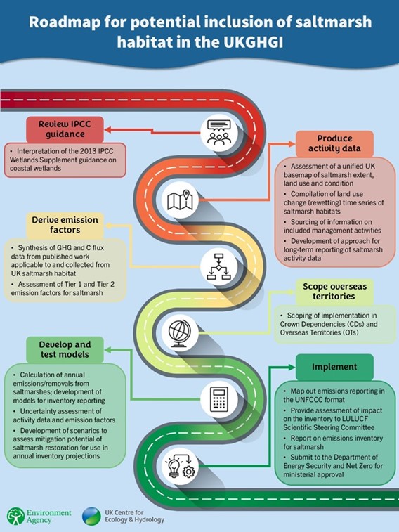
We have developed a pathway for including saltmarsh in the national GHG inventory and are working along this to fill key data gaps.
Key outputs
Key outputs towards development of a UK Saltmarsh inventory include:
Defining saltmarsh and roadmap for its potential Inclusion in the UK Greenhouse Gas Inventory (GHGI)
This project set out a clear, UK-wide approach for defining, mapping and reporting saltmarsh habitats. It provides a recommended definition for UK saltmarsh from an assessment of saltmarsh terminology and mapping, and sets out a framework for reporting saltmarsh in the GHG inventory. The project engaged with experts from across the UK’s devolved governments to agree consistent terminology, identify key management activities and explore how saltmarshes could be represented within the Land Use, Land use Change and Forestry Sector of the UK GHG Inventory.
Saltmarshes are intertidal areas that generally occur between (but are not restricted to) mean high-water spring tides and mean high-water neap tides (with transitional elements to Highest Astronomical Tide) at temperate latitudes and are colonised by halophytic flora. However, the position of saltmarsh is context dependent, and variations around this ‘rule of thumb’ occur.
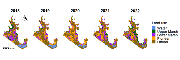
Monitoring UK saltmarsh restoration using earth observation for national greenhouse gas accounting
Using satellite imagery processed through Google Earth Engine, we developed an Earth Observation method to monitor vegetation change across UK saltmarsh restoration sites. This approach provides a living picture of saltmarsh recolonisation, which can be used to assess habitat recovery and restoration success over time. The method successfully distinguished between vegetated and bare sediment, with over 90% accuracy, generating a time series of saltmarsh extent, which is key for estimating greenhouse gas emissions and removals per unit area of saltmarsh creation.
Database of saltmarsh carbon stock and GHG flux data applicable to the UK
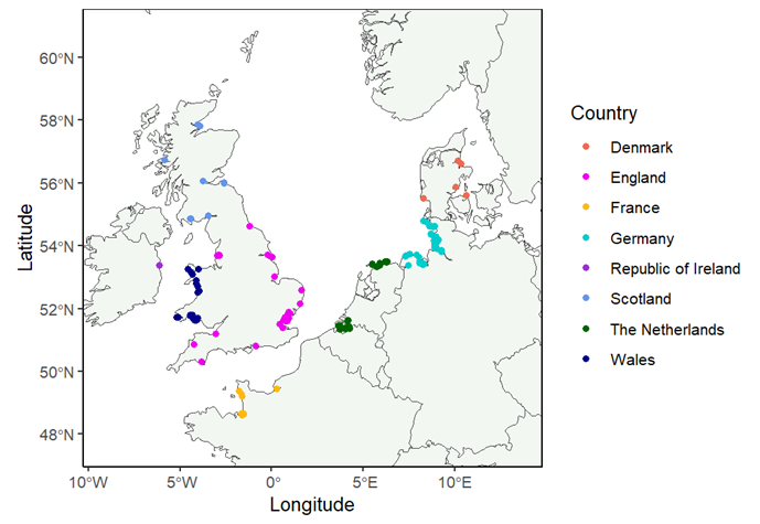
A literature review of saltmarsh carbon stock and GHG flux data applicable to the UK from a Web of Science search was conducted in 2023 to develop a UK saltmarsh database of GHG fluxes (CO2, CH4, and N2O) and carbon accumulation and stocks for natural and restored saltmarsh. The search returned 8,974 papers, which were rigorously screened down to 103 selected papers and data repositories for incorporation in a database. These data are deposited with the Environmental Information Data Centre, and have been used in follow-on projects described below to visualise the data and develop emission factors.
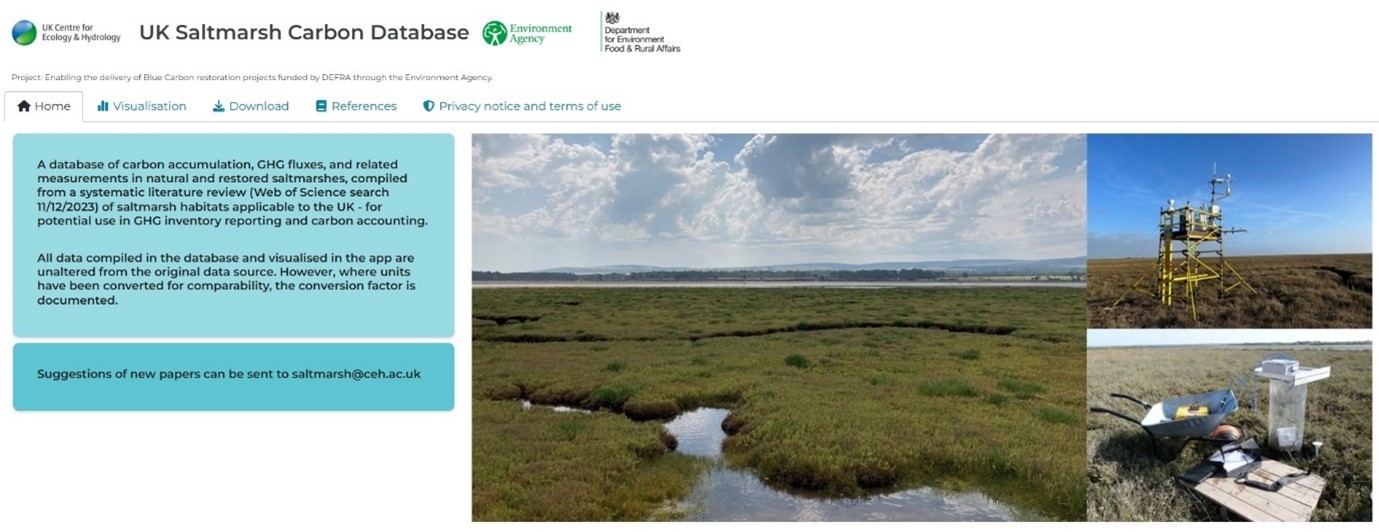
UK Saltmarsh Carbon Database web tool
This is an interactive, open access platform that visualises compiled measurements of carbon accumulation and GHG fluxes from natural and restored saltmarsh, based on data from the systematic literature review. The tool provides a living database that users can query, download from, and contribute to by proposing new datasets. This ensures transparency and continuous improvement of emission factors in national GHG inventory reporting. In the future, the database will also be informed by outputs from the Saltmarsh Flux Tower Network - seven sites around the UK where carbon dioxide is measured continuously via eddy covariance.
Assessment of default (Tier 1) and country-specific (Tier 2) emission factors for saltmarsh
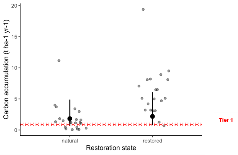
This research has developed empirically based Tier 2 carbon accumulation (carbon sink) and methane emissions (CH4 source) for UK saltmarshes: -1.83 t C ha-1 yr-1 and 6.26 kg CH4 ha-1 yr-1, respectively. These figures represent conditions relevant to UK saltmarshes for potential reporting in the UK GHG inventory. When converted to carbon dioxide equivalents (using a CH4 global warming potential of 28), these values equate to a net GHG sink of -6.53 t CO2e ha-1 yr-1 for natural saltmarsh. Restored saltmarshes exhibited slightly higher carbon accumulation, though further research is needed to determine the length of time this enhanced rate persists following restoration. More details are available in the associated report.
Baseline mapping
We are developing a unified UK basemap of saltmarsh extent, including land-use and condition where data is available. This is an essential step in the roadmap towards inclusion of saltmarsh in the UK GHGI as it will enable changes in land-use and management (eg restoration activities) to be assessed over time.
To meet the simplest level of reporting requirements, a country can apply default IPCC emission factors (IPCC, 2014) to national activity (eg area) datasets. This requires a basemap for calculating emissions and removals per unit area of saltmarsh and also acts as a reference point in time for estimating the impact of human activities on saltmarsh.
Notable milestones within this project are:
- Dataset identification and comparison – documenting all metadata, including assumptions the data are built on and differences between datasets, and exploring if there is a harmonised methodology for bringing together UK-wide mapping.
- Literature review of how other countries have interpreted the IPCC Wetlands Supplement requirements and how saltmarsh is represented in their inventories
- Creating the basemap of saltmarsh extent in a given reference year (or years, if data allow).
- Collation of saltmarsh restoration data to allow calculation of changes to the saltmarsh area over time
- Literature review of existing methodologies to monitor change in saltmarsh extent and condition over time
- Develop an Earth Observation approach for mapping saltmarsh extent and condition annually, and to track change over time in both restored and natural saltmarsh.
Publications
Burden, A, Clilverd, H, Carter, S, Garbutt, A, Green, B, Stanford R, Gomez Castillo, A P. 2024. Defining saltmarsh and the roadmap for its potential inclusion in the Land Use, Land Use Change and Forestry (LULUCF) Inventory. Report to the UK Blue Carbon Evidence Partnership (UKBCEP). UK Centre for Ecology & Hydrology, Bangor. 54pp. Defining saltmarsh for inclusion in the LULUCF Inventory - ME5325.
Burden A, Clilverd, H. 2022. Moving towards inclusion of coastal wetlands in the UK LULUCF inventory. Report to BEIS.
Clilverd, H, Williamson, J, Nickerson, R, Garbutt, A and Burden A. 2025. Monitoring UK saltmarsh restoration using earth observation for national greenhouse gas accounting. Ecological Applications. DOI: 10.1016/j.ecolind.2025.113867.
Clilverd, H, Burden, A, Carter, S, Buys, G, Ferguson, S. 2024. Database of saltmarsh carbon stock and GHG flux data applicable to the UK. Documentation of the systematic literature review. Report to the Environment Agency. UK Centre for Ecology & Hydrology, Edinburgh. 31pp
Clilverd, H, Burden, A, Carter, S, Buys, G, Ferguson, S J. 2025. Saltmarsh carbon and greenhouse gas flux data for northern temperate Europe, collated from literature. NERC EDS Environmental Information Data Centre.
Dolan, R, Clilverd, H, Williamson, J, Burden, A. 2025. Developing a saltmarsh basemap: phase 1. For use in the UK Greenhouse Gas Inventory. Report to Cefas UK Centre for Ecology & Hydrology, Bangor. 16pp
Raine, E, Clilverd, H, Banin, L F, Garbutt A, Burden A. 2025. Assessment of Tier 1 and Tier 2 emission factors for saltmarsh. Report to the Environment Agency, UK Centre for Ecology and Hydrology, Edinburgh. 48pp.


