What is the FEH?

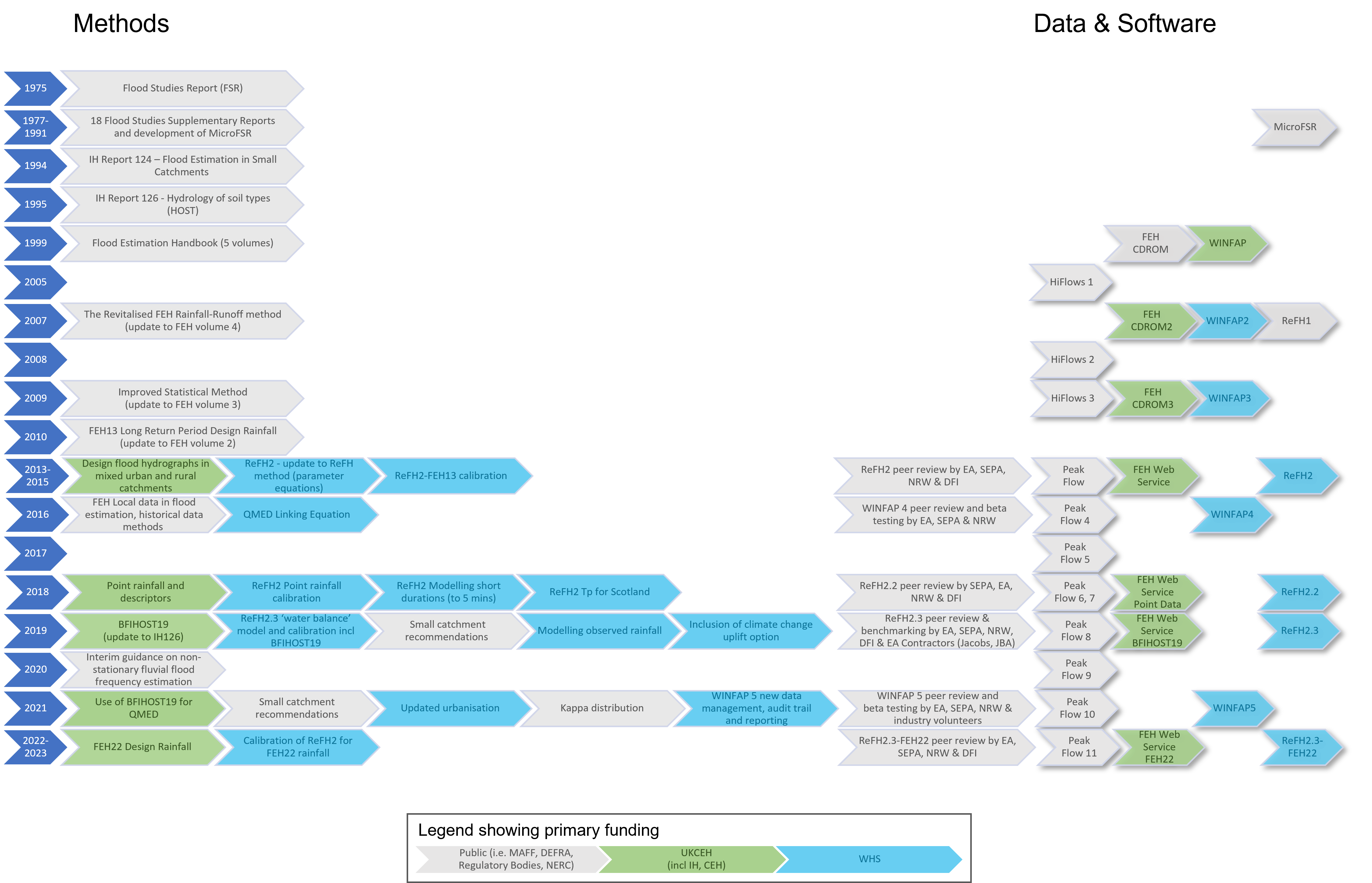
The Flood Estimation Handbook (FEH) and the earlier Flood Studies Report (FSR) are a set of methods and associated data to enable recognised standard national methods for rainfall and flood estimation, and rainfall-runoff modelling. They are based on calibration to large hydro-meteorological datasets from gauged locations across the UK.

FEH was first delivered as a 5-volume printed series (1999) and associated CD-ROM but has evolved into a much wider collection of updated and expanded methods, data and guidance. This includes the Revitalised Flood Hydrograph method (ReFH). All methods are open-access and links to all FEH and SFSR volumes and all UKCEH authored publications are provided in the project menu.

The FEH statistical method and ReFH are both available as software solutions (WINFAP and ReFH2) to enable industry applications of the methods. These are not managed by UKCEH and are available as commercial subscriptions from Wallingford Hydro-Solutions.

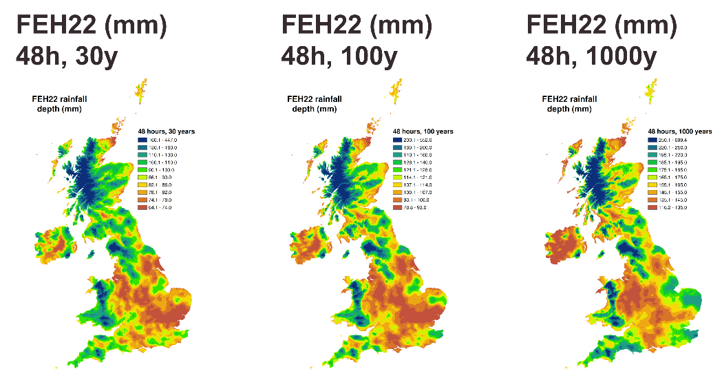
FEH and ReFH data and methods are the UK regulatory recommended methods for estimating river flood frequency and design rainfall in England (Environment Agency - EA), Scotland (Scottish Environment Protection Agency - SEPA), Wales (Cyfoeth Naturiol Cymru - NRW). The methods feed into national flood mapping such as the National Flood Risk Assessment (NAFRA).

FEH Web Service

The FEH Web Service is delivered by UKCEH and delivers catchment descriptors and rainfall data to support the methods outlined in the Flood Estimation Handbook (FEH), and implemented in the FEH software, for estimating floods and site runoff rates across the UK. The FEH Web Service is an enterprise level software solution, robustly designed with a corresponding level of service continuity to provide the flood hydrology community with access to essential and maintained data resources.

Income generated by the FEH Web Service’s community of users pays for the operation, maintenance and development of the FEH Web Service platform itself and is also re-invested into the underpinning scientific research to ensure the continual advancement in the FEH evidence base.

On the FEH Web Service is a guidance document on uncertainty quantification in FEH Web Service methods. This can also be downloaded below.


The Flood Estimation Handbook (FEH) Webservice

FEH22 rainfall DDF model and updates to the FEH Web Service

Download for uncertainty in FEH methods

FEH research and projects

Research into flood estimation methods and associated data is undertaken across a range of projects at UKCEH. These projects either directly or indirectly feed into developments in flood estimation methods and guidance for the UK. 

UKCEH actively engages with UK stakeholders and users of FEH methods and data. For research and projects feeding into changes in operational guidance on using UK flood estimation methods this involves regular communication with UK regulating agencies to ensure any updates are reviewed and feedback incorporated. This co-production of FEH methods and data ensures developments are fit for purpose and guided by the needs of the wider hydrological community.

Update of the FEH statistical method – started Jan 2023 (ongoing) – UKCEH

This project, funded using reinvestment of income from the FEH Web Service, is looking at novel directions to take the current methods for estimating QMED and pooling, using updated catchment descriptions and more hydrometric data. New areas being explored are national methods for including urban effects, refining urban thresholds, incorporating peak-over-threshold (POT) data, and seasonal effects. The project aims to deliver an updated statistical method in 2023. 

Incorporating climate change effects into flood estimation methods – 2023 (ongoing) – UKCEH

Current FEH methods do not account for or consider climate change effects – either in recent records or in the future. This project aims to assess what related guidance and research there is in this area and to highlight what tools or data is relevant to apply when considering climate change effects on rainfall and river flow estimates. It will outline a programme of work to incorporate evolving data such as the Met Office UKCP Local data into flood estimation methods. 

Hydro-JULES flood event signatures – 2023 (ongoing) – NERC

The next phase of the Hydro-JULES research programme includes a component looking at developing an open dataset of flood events from high resolution hydrometeorological data. This will be used to develop a flood event archive of events so that we can learn more about how different responses are driven by catchment processes. It will also involve exploring machine learning potential. This will in time be used as building blocks for next generation flood frequency approaches. 

Changes in short-duration rainfall in Scotland – 2022 (ongoing) - Scottish Water

The FEH team have undertaken a study to investigate possible changes in short-duration rainfall in Scotland over the last few years, and looking forward out to the end of the 21st Century. This is supported by the development of the FEH22 depth-duration-frequency model, which has been employed to also investigate uncertainty in rainfall estimates.

Winter 2019-21 Floods – 2023 (ongoing) – Environment Agency

The Environment Agency has commissioned a study to examine the severity and rarity of a series of wide-reaching flood events from September 2019 to March 2021. This includes applying the full suite of FEH flood frequency and rainfall frequency approaches.

NCEA Network appraisal – 2023 (ongoing) - Defra & Environment Agency

As part of the NCEA programme, we have improved methods to quantify the representativeness of a subnetwork in describing the full river network of England. This ties in with existing network appraisal tools being implemented by UKCEH. This work could lead to developing measures of pooling group representativeness.

FEH22 - completed 2022 – UKCEH

The FEH22 model is the new industry standard for design rainfall estimation and is endorsed by UK regulators for all new flood estimation projects. This work was a major update of the previous FEH13 rainfall depth-duration-frequency (DDF) model. FEH22 incorporates rainfall data from over 11,000 sites across the UK, including around 2,000 sub-daily gauged sites compiled by the Hydro-JULES project.


FEH UK maps


Read the report [PDF]

Making better use of local data in flood frequency estimation - completed 2017 - Environment Agency 

Flood frequency estimates, also known as design flood estimates, are associated with many sources of uncertainty. These are often the most uncertain component in any flood risk assessment. As a result, any reduction in the uncertainty of flood frequency estimation has considerable benefit. One way to reduce uncertainty is to incorporate complementary local data to refine the results obtained using the FEH methods.

Estimating flood peaks and hydrographs for small catchments - Environment Agency 

The study has focused on flood estimation in small rural and urban catchments in the UK. 

Phase 1 (2012) reviewed existing techniques available for flood estimation in ungauged small rural and urban catchments and suggest a preferred technique or suggest further research.

Phase 2 analysed datasets, and developed techniques to produce tools to enable reduced uncertainty for flood estimation in small catchments. This work is complete as of 2023 and is awaiting release by the Environment Agency.
 

BFIHOST19 -  completed 2022 - UKCEH

The estimate of the base flow index (BFI) based on the Hydrology of Soil Types (HOST) classification, BFIHOST, provides a measure of catchment responsiveness. BFIHOST is used with other variables to estimate the median annual maximum flood (QMED) in the UK standard Flood Estimation Handbook (FEH) statistical method and is also an explanatory variable in ReFH2, the FEH design hydrograph package. The new BFIHOST19 descriptor is now available for catchment and points alongside the original BFIHOST data. The new BFIHOST19 descriptor addresses a number of issues in the original BFIHOST developed in 1995. 
 

Non-stationary fluvial flood estimation - completed 2021 - Environment Agency

The main aim of this project was to develop interim guidance for dealing with nonstationarity in annual maximum river flow series. 

The objectives were to:

  • develop methods for identifying non-stationarity in annual maximum flow series 
  • develop a scientifically robust process for carrying out non-stationary flood frequency analysis 
  • outline how to take account of future climate change under non-stationary conditions 
  • provide guidance and tools for practitioners to carry out non-stationary flood frequency analysis 
  • make a high-level assessment of the impact of allowing for non-stationarity on flood frequency estimation across England and Wales

Funding

FEH methods

Funding for the development and maintenance of FEH methods and related software and data has evolved over time since its inception in 1999. The original five volume series and its associated software tools were published in 1999, representing the results of a five-year programme of strategic research at the Institute of Hydrology (IH). The research was funded primarily by the Ministry of Agriculture Fisheries and Food (MAFF, predecessor to Defra) with additional support from the National Rivers Authority (NRA, predecessor to the Environment Agency), the Department of Agriculture Northern Ireland and a consortium led by the Scottish Office.

Subsequent developments including the automation and update of the FEH statistical method in the WINFAP package and development and associated software for the ReFH rainfall-runoff model were funded by Defra and the Environment Agency. Recent developments include the EA funded small catchments project to provide guidance on flood estimation in small catchments. The FEH Web Service replaced the CD-ROM and was funded by UKCEH.

The graphic below, developed by Wallingford Hydro Solutions (WHS), illustrates the historical development of FEH methods, data and software – highlighting the funding sources for each development step. 

FEH methods - historical development

Click the image to view larger version or visit: History, present and future of the FEH. © Wallingford HydroSolutions 2023

FEH Web Service 

Funding for the operation and maintenance of the FEH Web Service is provided by the user community through a “user pays” business model designed to provide sustainable and secure long-term funding without sole reliance on the public purse.

Income generated by the FEH Web Service’s community of users pays for the operation, maintenance and development of the FEH Web Service platform itself and is also re-invested into the underpinning scientific research to ensure the continual advancement in the FEH evidence base. These advancements are guided by regular consultation with the UK regulatory agencies, and liaison with the wider scientific and user community, along with availability of data. This has driven recent updates to content including catchment descriptors (e.g. BFIHOST19) and the FEH depth-duration-frequency model (FEH22), alongside updates to FEH Web Service functionality such as the user interface and data management functions. 

FEH Team

Adam leads the FEH team and has responsibility for managing the FEH team, directing FEH R&D within UKCEH, linking research with the software delivery partner Wallingford HydroSolutions, and liaison with wider industry and regulators. He is a hydrological statistician who has worked on flood estimation with a focus on trends and the impacts of climate and anthropogenic change on flood frequency estimation methods.
Gianni is a hydrological modeller in the Flood Estimation Handbook (FEH) team at UKCEH. Gianni's work focuses on the development of the FEH methods, including the new FEH22 rainfall depth-duration-frequency model implemented in ReFH2 software, and the statistical flood frequency model implemented in WINFAP software. Gianni works closely with Wallingford HydroSolutions and the UK's environmental regulators to translate advances in science and data into usable methods and guidance for practitioners.
John is a mathematical modeller working on hydrological modelling to support UKCEH products such as G2G and FEH. John has been working on refining catchment descriptors and assessing the potential for more physically plausible representation of reservoir and lake attenuation effects and floods.