- An operational framework for a flexible, scalable and future-proof community Emission Modelling System implemented on JASMIN
- A process for a community-driven, co-designed UK-EMS enabling the atmospheric modelling community to generate emission input data at the spatial, temporal and substance resolution required for a wide range of use cases.
- An open, accessible system and demonstrators for the integration of novel emission calculation methods, including approaches for future expansion.
- The operational integration of anthropogenic and biogenic emissions into consolidated output datasets.
- A consistent approach for the provision of temporally and spatially resolved emission data across a range of scales.
- A demonstrated output generation process for frequently used data formats, including meta-data and supporting documentation of the calculations included, and open for future extension to new formats.
Key deliverables
Engagement
User and stakeholder engagement are critical to the development of the Emission Modelling System, as it will need to be tailored to the needs of the immediate users - the UK atmospheric modelling community. In addition, the flexibility of the UK-EMS towards further development and future expansion will require a thorough discussion with potential users of atmospheric modelling results, taking note of their likely future evidence needs.
A User Group has been set up to achieve these objectives, drawing on atmospheric modelling experts both within the SPF Clean Air Programme and from the wider UK modelling community. A Stakeholder Group will also be formed, including representatives of the funding agency, the wider SPF Clean Air Programme and UKRI, Defra, BEIS, Devolved Administration authorities, and other regulatory and arms-length bodies with an interest in air pollution. The aims of the stakeholder group will be to support the identification of future directions for development and review the recommendations for priorities for future activities emerging from the research team and UG conversations.
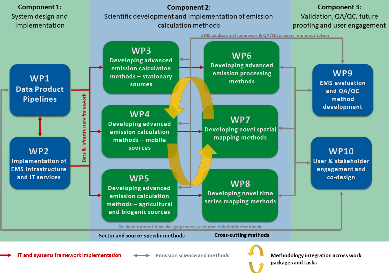
Project structure and workflow
Desired outcomes
- Demonstrate support for input and output data at spatial resolutions suitable for UK national scale down to finer scales appropriate for urban, street scale and road network investigations (sub-kilometre), and temporal resolutions from sub hourly, to hourly and further aggregated timescales
- Support past and future projection input datasets, manipulation and outputs.
- Support temporal variations recorded in input data and as part of UK-EMS processing, such as traffic cycles. Enable multiple and adjustable temporal profiles, merging multiple input datasets, application of emission factors, and the ability to make incremental adjustments to support uncertainty analysis, for example.
- Support wide-ranging processing of emission data (such as application of emission factors or emission reductions) to generate UK-EMS outputs. Include or facilitate aggregation and/or disaggregation of species to bridge between emission data and model schemes.
- As a minimum ensure the UK-EMS can easily be extended to support needs for emission verification, such as top down observation-based approaches. Have the ability to compare datasets and processing choices, the flexibility needed to enable users to explore the use of alternative datasets, and provide documentation and analysis of errors and uncertainties.
- Regular reporting, including a community engagement event to guide development, early demonstration of research code structure, approach and capability, and indication of publications demonstrating impact and benefit of UK-EMS for air quality modelling and analysis.
- Development of a UK-EMS that supports data access, hosting, processing, analysis and production of modelled emissions with temporal and spatial scales suitable for UK national to urban atmospheric air quality modelling and analysis.
- Support research into, use of and access to numerous anthropogenic and biogenic emission inventories and datasets, over a range of temporal and spatial scales.
- Support and demonstrate the addition of new emissions, including additional species such as biogenic volatile organic compounds, intermediate-volatility organic compounds, ultra-fine particles, and sources such as spatial and temporal maps of domestic biomass emissions.
- Support and include access to a range of existing anthropogenic and biogenic emissions inventories, for example, the NAEI, London, and EMEP, as well as relevant additional data, for example, activity data. Provide the ability to calculate emissions from input data such as activity data, linking multiple species together into modelled species.
- Support input data in a range of standard data formats, such as NetCDF, XML, and JSON.