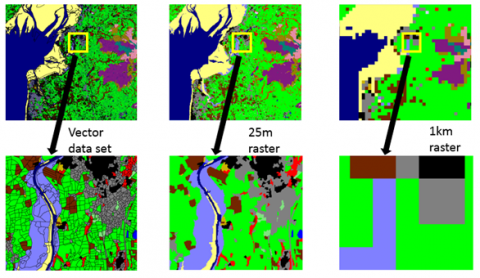
Academic research and education
All of UKCEH’s Land Cover Maps are available for free to users of the EDINA Environment Digimap service which includes staff and students at more than 100 UK further and higher education establishments.
Non-commercial use of raster data
All of UKCEH’s raster Land Cover Maps (all 20m, 25m and 1km raster datasets) are available to download and use for free for non-commercial organisations and their contractors from the UKCEH Environmental Information Platform:
Non-commercial use of vector data
Non-commercial organisations and their contractors can access all vector Land Cover Maps from UKCEH under licence. While data fees will not be charged, administration fees (total of £300 plus VAT) will apply. A condition of the licence is that detailed information on how the data are used is provided, in order for UKCEH to improve our product development and stakeholder engagements. Understanding how and where our data are being used is very important to UKCEH. Please make a request using this licence application form (Word).
Commercial internal business use
All of UKCEH’s Land Cover Maps are available for commercial internal business use under licence and subject to payment of a licence fee. Please make a request via our web form, email Spatial Data or or telephone +44 (0)1491 692716 for more information.
Innovation use and value-added reselling
UKCEH encourages use of its intellectual property in value added products and services. Our intellectual property can be made available without charge for Innovation Use in order to allow feasibility studies and the development of products and services prior to arranging a bespoke value added reseller agreement. Please make a request via our web form, email Spatial Data or telephone +44 (0)1491 692716 for more information.
Web mapping service
UKCEH provides a Web Mapping Service for all Land Cover Map 25m and 1km raster data. Using our map viewer, high-resolution data for the whole of Great Britain can be seen, but not downloaded. Images of Land Cover Map data can be captured but, if these are published, they must be acknowledged appropriately.