The Monks Wood 'Wilderness' experiment

Long-term natural colonisation of woodland on former farmland

Introduction

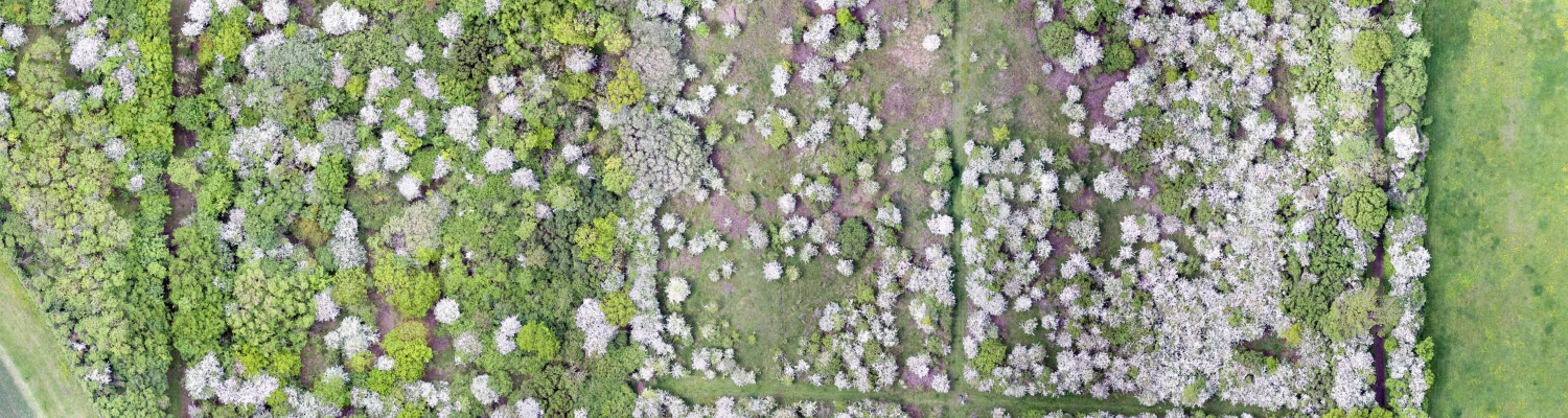
The Monks Wood 'Wilderness' sites are a series of former fields of arable farmland and grassland, which are next to the ancient woodland of Monks Wood National Nature Reserve in Cambridgeshire, eastern England. The fields have been taken out of farming production or management and allowed to return to woodland by natural succession for up to 60 years, with no management or inputs. The sites are a long-term study of passive rewilding and woodland colonisation and succession, and represent one of the most comprehensive examples in Britain.

The term 'Wilderness' was given to the sites in the 1960s as a (light-hearted) reference to the dense shrub thickets that initially developed, an impenetrable wilderness! The sites have since been monitored as closed-canopy woodland has developed, and have been regularly surveyed using ground-based fieldwork and remote sensing (LiDAR, drone) to map the vegetation changes over time.

With a growing interest in rewilding and a desire to expand woodland cover in Britain, the results of the Monks Wood Wilderness experiment provide valuable information for the timescales, patterns and processes of woodland natural regeneration on former farmland.

ASSIST Monks Wood ASSIST Monks Wood ASSIST Monks Wood


The experiment

In 1961, the first Wilderness site was established on a 4 ha arable field of barley, which had been ploughed and then abandoned after the final harvest. This field was originally deforested in the Roman period, and had been cultivated or grazed ever since. Kenneth Mellanby, the founder and Director of the Monks Wood Experimental Station (part of the precursor to UKCEH) wrote in his notes: "It might be interesting to watch what happens to this area if man does not interfere, for instance, if it will become a wood again, how long will this take, which species will be in it?". These questions can now be answered. This field was first surveyed and photographed in May 1967, when all tree and shrub seedlings were mapped across 0.9 ha of the site. As can be seen in images below, by 2014 the whole field had become woodland.

ASSIST Monks Wood ASSIST Monks Wood ASSIST Monks Wood

A further 2.1 ha field was established as an additional Wilderness site on grassland in 1996, which was deforested some time between the 17-19th Centuries. This provded a comparison with the initial ground conditions (ploughed) on the first Wilderness. A rolling programme of field surveying, tagging and mapping of trees was initiated on both Wildernesses by Tim Sparks from the late 1990s, using a 20 m grid of permanent markers in the developing woodlands.

Floral surveys were led by Owen Mountford, and bird surveys by Shelley Hinsley and Paul Bellamy. Between 2000-2014 a series of LiDAR surveys of vegetation development was also undertaken, led by Ross Hill, and from 2019 drone surveys and further fieldwork was initiated by Richard Broughton. This time series of data for both Wildernesses is unique, and provides a comaprison with the adjacent ancient woodland of Monks Wood, which is documented back to at least 1279 AD. Monks Wood is a rich source of tree and shrub seeds, and species that can disperse them (e.g. Jays, Grey Squirrels and Wood Mice) alongside wind, and so is an ideal scenario for natural colonisation of woodland.

However, Monks Wood and the Wilderness sites are also host to many herbivores that could inhibit woodland regeneration, such as wild Rabbits, Brown Hares, Muntjac Deer (colonised in the early 1970s) and Roe Deer, which have been common or abundant in various periods over the decades. The experiment is therefore a study of the ability of woodland to regenerate on abandoned land under ideal conditions of seed source availability (proximity & dispersal agents) but also under the presence of inhibitors (deer, Rabbits).

ASSIST Monks Wood ASSIST Monks Wood ASSIST Monks Wood


How was the work carried out?

In the study, surveys of trees and shrubs in the two Wilderness fields were carried out at up to 24 years and 59 years since abandonment, including the tree size and species composition. These inventories were compared with surveys from the adjacent Monks Wood, to see if and how species composition, tree density and shrub species frequency differed between the Wildernesses and the woodland that was the seed source. We wanted to know what type of tree and shrub community was becoming established on the Wilderness fields, and how quickly it developed. We performed spatial analyses and modelling to see if the pattern of tree establishment was clumped or random/uniform across the sites.

ASSIST Monks Wood ASSIST Monks Wood ASSIST Monks Wood

We also used airborne LiDAR and drone structure-from-motion methods to characterise the coverage and height of the shrub and tree vegetation, across the whole of the two Wilderness sites. Repeat surveys by remote sensing gave a time series of vegetation change for the years 2000, 2005, 2012, 2014 and 2019. These surveys mapped the vegetation at 1 m resolution, to show how the shrub layer and tree canopy progressed over the decades. This also allowed us to compare the maturity of the oldest Wilderness plot with the local woodlands, to see how far the tree canopy height of the new woodland had converged with ancient woods nearby.

ASSIST Monks Wood ASSIST Monks Wood


What did we find?

The study found that the Wilderness fields were colonised very rapidly by woodland shrubs and trees. During the initial decades after land abandonment, colonisation was dominated by thorny shrubs, which formed a blossom-rich habitat for several decades. This shrubland apparently protected the tree seedlings that grew amongst it, and which eventually grew over the shrubs to form a tree canopy. After 23 years of regeneration on the younger Wilderness field, there was 86% coverage of shrubs and young trees, with vegetation averaging 2.9 m tall. The older Wilderness field had essentially achieved complete coverage of closed-canopy woodland after 53 years, averaging 13.1 m tall. By this stage, the structural characteristics of this Wilderness were approaching those of the neighbouring ancient woodland. However, the woody species composition of both Wildernesses differed from the ancient woodland of Monks Wood, being dominated by animal-dispersed Oak and berry-bearing shrubs, especially hawthorn.

It appeared that the early-colonising thorny shrubs were deposited by berry-eating thrushes feeding on the open ground, while acorns were planted by Jays, Grey Squirrels or Wood Mice. The minority of Ash, Maple, Birch and Elm trees colonised by wind dipersal or suckering. Wind-dispersed Ash was more common on the field that had initial ground disturbance (ploughing), allowing the lighter seeds to reach the soil more easily than on grassland. Tree colonisation was spatially clustered, with Ash mostly occurring nearer to seed sources in the adjacent woodland, while Oaks were more widely distributed in clusters, probably due to patterns of widespread acorn hoarding by the Jays and rodents.

After 24 years the density of live trees in the younger Wilderness was 132/ha (57% Oak), with 390/ha (52% Oak) in the older Wilderness after 59 years. Deadwood accounted for 8% of tree stems in the former and 14% in the latter. Herbivores, such as deer and Rabbits, did not appear to have seriously hindered the developement of the new woodland, despite no fencing or culling on the Wilderness sites themselves, probably due to the natural protection provided to tree saplings by the thorny shrubs and bramble.

The passive rewilding of these Wilderness sites shows that closed-canopy woodland can quickly re-establish on abandoned farmland close to existing woodland, with no management or inputs, and it was resilient to the presence of herbivores and also to numerous summer droughts. After an initial phase of shrubland, Oak-dominated native woodland was achieved within 50 years.

ASSIST Monks Wood ASSIST Monks Wood


Acknowledgements

Many researchers and fieldworkers have contributed to the monitoring of the Monks Wood Wildernesses over the decades, including staff from UKCEH and its precursors (ITE/CEH) and students from universities in the UK and across Europe. Kenneth Mellanby had the original vision of a monitored Wilderness site, and Tim Sparks and Owen Mountford were fundamental to continuing and expanding the studies. Ross Hill was instrumental in the remote sensing campaign.

The lidar data were acquired by the Environment Agency, the Natural Environment Research Council’s Airborne Research and Survey Facility (ARSF) and the Unit for Landscape Modelling (ULM) at Cambridge University. Drone data were captured & processed by Charles George.