An open air laboratory for studying the environment – 50 years and counting

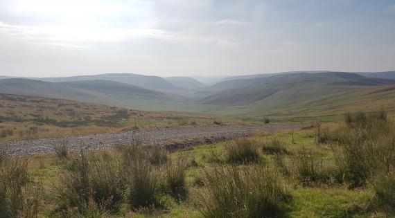
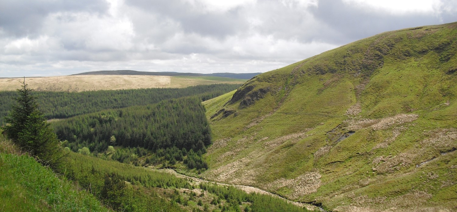
In the 1960s, the fledgling Institute of Hydrology, now part of the UK Centre for Ecology & Hydrology (UKCEH), launched an ambitious project on the eastern slopes of Plynlimon in upland Wales to examine water use by conifer forests. That project has since become a multi-disciplinary long-term paired catchment study leading and underpinning hydrological and hydrochemical research in the UK and internationally.

Image
Long history of Plynlimon Research

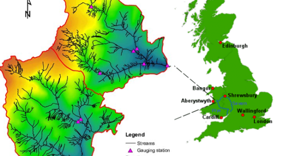
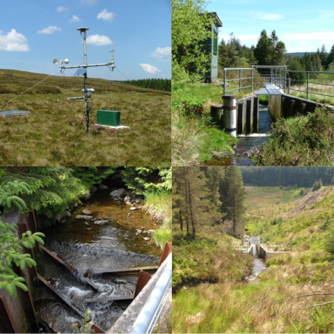
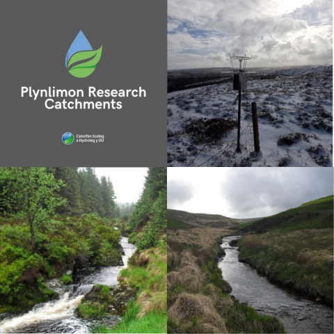
The Plynlimon Research Catchments (PRC), in the headwaters of the Severn and Wye rivers, are adjacent catchments (19.25 km2) with contrasting land uses: moorland and plantation forest. PRC monitoring and data collection combine the best elements of traditional methods and state-of-the-art technology, and the experimental catchments provide an outdoor laboratory for cross-cutting scientific studies. Three sub-catchments are nested within each main catchment, all with permanent flow gauging structures supported by automatic weather stations.

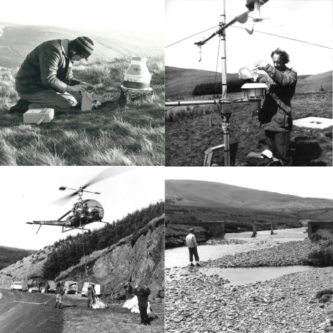
PRC now has over 50 years of high resolution river flow and meteorological data, supplemented by process studies on flow pathways, forest interception and evaporation. The hydrochemical record from PRC consists of more than 35 years of uninterrupted weekly to monthly deposition and stream water samples analysed for a range of constituents including pH, alkalinity, nutrients, major cations, anions, trace metals, DOC and DON.

Image
Plynlimon Catchments

At times "routine" Plynlimon monitoring has been expanded with detailed plot and small catchment-scale studies of flow generation, weathering and element cycling, and biological processes. The PRC platform has been used to study biogeochemical responses of upland catchments to acid deposition, forest harvesting, agricultural management and climate change. High temporal resolution sampling has been used to develop new mathematical and statistical methods for interpretation of short and long-term chemical trends. Data from PRC have also been used to inform development and calibration of a number of widely used hydrological and biogeochemical models.

Image
Plynlimon Catchments

Plynlimon research findings have been reported in more than 500 papers in refereed journals. Much of the Plynlimon record has been freely available to the international research community for decades, and is accessible via the UKCEH EIDC.

Podcast

Listen to an Ecological Continuity Trust podcast about Plynlimon (recorded 2022)

Image
Map showing location of Plynlimon monitoring site

Scientific importance

Right: Map showing location of Plynlimon monitoring site.

Upland sites have traditionally been exploited for livestock grazing, timber production and salmonid fisheries, but are also of high conservation and amenity value and important for water resources and carbon storage. In addition, as a result of high rainfall and low permeability soils, a disproportionate amount of floodwaters can be generated from upland catchments. Land use changes affect the overall catchment water balance by influencing evaporation rates.

The Plynlimon Research Catchments are two, almost identical, adjacent uplands catchments, with the exception that one is used for grazing sheep while the other is mostly under plantation conifer forestry. Intensive and long-term monitoring within the catchments underpins a wealth of hydrological and hydro-chemical research. The combined datasets include river flow, rainfall, cloud and stream hydro-chemistry, meteorology and a variety of detailed spatial datasets representing the topography, soils and rivers of the catchments.

This information is used to look for time trends, understand the processes operating, and investigate the impacts of land use on water resources, floods, drought flows, stream sediment and dissolved chemicals and acidification.


Read more about the Plynlimon Research Catchment experimental design.

About the site

The catchments, which cover a combined area of 19.25 square kilometres, are located within the headwaters of the River Severn and the River Wye, on the east flanks of Plynlimon Fawr, a 750 metre peak, located approximately 20km inland of Aberystwyth, which is on the mid-Wales coast. The catchments are upland in character, being between 300 metres to 700 metres above sea level. The climate is wet and cool. The annual rainfall is around 2500 mm and the mean annual mean temperature is 7 degrees centigrade.

The geology and soils of the catchments are similar. The geology comprises mainly of fine grained sediments (mudstones, sandstones and slates) which have been folded and faulted. Some of the faults have been mineralised (lead).

The soils in both catchments are acidic in nature, dominated by Blanket Peats and Stagnopodzols. In both the catchments, there are also areas of valley bottom peats and alluviumn which follow the main rivers and areas of Gley soils. The Severn catchment has some areas of Brown earths. 

The northern catchment has an area of 8.7 square kilometres. It comprises the headwaters of the River Severn (Welsh: Afon Hafren) which lies mainly within the Hafren Forest. Conifer plantation is the dominant land cover. It covers roughly 70 percent of the catchment. The rest of the catchment is covered by acid grassland and blanket bog. The forest area in the catchment is owned and managed by Natural Resources Wales. The area outside the forest is privately owned.

The larger southern catchment, with an area of 10.55 square kilometres, comprises mainly acid, semi improved and improved grass lands and encloses the source of the River Wye (Welsh: Afon Gwy). The land in the catchment privately owned. Although there is some localised groundwater present, investigations have indicated the catchments can be regarded as watertight.

Image
Plynlimon (GGR)

Results & publications

The original aim of the Plynlimon catchment experiment was to provide data to resolve the controversy concerning the water use of conifer forest plantations versus grasslands in the catchment areas of upland UK reservoirs. The study pioneered the use of paired-catchment experiments and subsequently developed into a long-term multi-disciplinary project. Building upon the established catchment infrastructure, hydrochemical measurements were introduced and now more than 35 years of water quality data are available together with the longer record of hydrological data.


Read more about Plynlimon research results in a special issue of Hydrological and Earth System Sciences.

Current & past research at Plynlimon

Alongside the long-term catchment and atmospheric monitoring within the Plynlimon Research Catchments, other projects utilise the facility and the access to the vast quantity of historical data. These include or have previously included:

Greenhouse Gas Removal (GGR) via Enhanced Rock Weathering demonstrator: Plynlimon Rockdust

An experiment is to test the GGR potential of ERW (rockdust) in upland grasslands via the application of a basalt rock dust over a 3-year period. This project is a major demonstrator in the Enhanced Rock Weathering Project as part of the high-profile Government funded UKRI GGR programme.

Find out more

UK Soil Observatory

The UK Soil Observatory (UKSO) have been monitoring soils since the beginning of the last century, with many years of research experience, collecting tens of thousands of soil samples and performing hundreds of different analytical methods. This represents millions of pounds of research investment and has created a powerful data resource for soil research in the United Kingdom and Europe. We are all working to make more of our datasets readily visible and accessible through the UKSO. Observatories and long term monitoring sites play a vital role in our current research of soils across the UK. Numerous observatories (and networks of observatories) are currently managed by UKSO partners including Plynlimon at UKCEH.

Find out more

Ecological Continuity Trust registered site

The Ecological Continuity Trust currently supports 36 active experiments at 37 sites in the United Kingdom and the community is constantly growing. The Plynlimon Research Catchments are a member of the ECT network. 

Find out more

UK Upland Waters Monitoring Network

The UK Acid Waters Monitoring Network (now the UK Upland Waters Monitoring Network) was set up to provide crucial chemical and biological data on the extent and degree of surface water acidification in the UK uplands, in particular to underpin the science linking acid deposition to water quality and to monitor the response of aquatic ecosystems to reductions in air pollution. The water chemistry and biological data provided by the UK UWMN provide the highest quality datasets for the development and application of Critical Loads models which are used on a national basis for the provision of data for freshwater ecosystems under the UN-ECE Gothenburg Protocol.

Find out more

SoilTrEC and Critical Zone Observatory

Plynlimon also acts as a satellite 'Critical Zone' observatory site. The CZ is the environment that extends from the top of the tree canopy to the bottom of our drinking water aquifers; it is where terrestrial life flourishes and feeds most of humanity. The heart of the CZ is where soils are formed, degrade and provide essential ecosystem services. The Critical Zone observatory project aims to investigate and model the processes determining soil sustainability in Europe. Data from the site will be used to test biogeochemical and nutrient models for SoilTrEC. Plynlimon is part of an international network of sites, located over similar geological units, studying processes of soil development across climatic and land use gradients; other sites are in the USA and China.

Find out more

COSMOS soil moisture network

The UK Centre for Ecology & Hydrology has established, and continues to grow, a long-term network of soil moisture monitoring sites for the United Kingdom, with funding from the Natural Environment Research Council. The network provides near-real time soil moisture data for use in a variety of applications including farming, water resources, flood forecasting and land-surface modelling. Each site is equipped with an instrument that uses cosmic-rays to sense soil moisture over an area of about 12 hectares (about 30 acres). Data from the network have the potential to transform the way that we understand and model the natural environment.

Find out more

SMART Watershed Network

The SMART Watershed Network maintained by several Lancaster University projects, in collaboration with numerous other institutions in the UK and overseas, is a platform for evaluating the latest hydrological, climatic and water quality sensors and in parallel evaluating the latest dynamic models of the resultant high frequency data. We wish to show how such a network not only delivers fundamental research in extreme tropical and temperate environments, but also research that has impact with the international water and forestry sectors.

Find out more

DURESS

DURESS (Diversity of Upland Rivers for Ecosystem Service Sustainability) led by Cardiff University is part of a NERC initiative to assess the role of biodiversity in delivering key ecosystem services. It brings together a consortium of 28 researchers from a range of disciplines and institutions, and is actively supported by seven key stakeholders who represent the water industry, the leisure industry, policy-makers, land owners and land managers. The Plynlimon catchments were chosen as part of the project because of its infrastructure and long-term data sets available for water chemistry and river flow. DURESS studies at Plynlimon included leaf litter, nitrogen and DOC addition experiments, stream biota monitoring and the installation of spectrometer probes at two sites.

Find out more


Contact

Data Curation and Further Information

Right: Watch a short video about UKCEH's work on long-term monitoring sites including Plynlimon.

As National Capability funded by the Natural Environment Research Council (NERC), all Plynlimon data are freely available for download from the Environmental Information Data Centre (EIDC). The EIDC is part of the Natural Environment Research Council's Environmental Data Service and is hosted by the UK Centre for Ecology & Hydrology.

Selected Publications

Selected Publications over the decades

2015. Strangeways, Ian; Robinson, Mark; Hudson, Jim; Rodda, John C.; Newson, Malcolm; Cooper, David J. Basin studies and instrumentation. In: Rodda, John C.; Robinson, Mark, (eds.) Progress in modern hydrology: past, present and future. Chichester, Wiley Blackwell, 23-59.

2011. Neal, C., Reynolds, B., Norris, D., Kirchner, J.W., Neal, M., Rowland, P., Wickham, H., Harman, S., Armstrong, L., Sleep, D., Lawlor, A., Woods, C., Williams, B., Fry, M., Newton, G. and Wright, D. Three decades of water quality measurements from the Upper Severn experimental catchments at Plynlimon, Wales: an openly accessible data resource for research, modelling, environmental management and education. Hydrological Processes, 25: 3818-3830. https://doi.org/10.1002/hyp.8191

2007. Clark, R. T. and Neal, C. Preface "A View from the Watershed Revisited" (Special Issue). Hydrology and Earth System Sciences, 11: 2–2 https://doi.org/10.5194/hess-11-2-2007

2004 Evans, C.D.; Reynolds, B.; Curtis, C.J.; Crook, H.D.; Norris, D.; Brittain, S.A. A conceptual model of spatially heterogeneous nitrogen leaching from a Welsh moorland catchment. Water, Air and Soil Pollution: Focus, 4 (6). 97-105. https://doi.org/10.1007/s11267-005-3019-7

2000. Kirchner, J., Feng, X. & Neal, C. Fractal stream chemistry and its implications for contaminant transport in catchments. Nature, 403: 524–527 (2000). https://doi.org/10.1038/35000537

1997. Kirby, C; Neal, C.; Turner, H.; Moorhouse, P. A bibliography of hydrological, geomorphological, sedimentological, biological and hydrochemical references to the Institute of Hydrology experimental catchment studies in Plynlimon. Hydrology and Earth System Sciences, 1 (3): 755-763. http://www.hydrol-earth-syst-sci.net/1/755/1997/hess-1-755-1997.html

1992. Reynolds B, Emmett BA, Woods C. Variations in streamwater nitrate concentrations and budgets over 10 years in a headwater catchment in mid-Wales. Journal of Hydrology, 136: 155–175. https://doi.org/10.1016/0022-1694(92)90009-K

1987. Hornung, M., Reynolds, B., Stevens, PA., and Neal, C. 1987. Stream acidification resulting from afforestation in the UK evaluation of causes and possible ameliorative measures. In: Forest Hydrology and Watershed Management. IAHS Publication 167, 65-74.

1985. Newson, M.D. Forestry and water in the uplands of Britain - the background of hydrological research and options for harmonious land-use. Quarterly Journal of Forestry, 79: 113-120.

1979. Newson, M.D. The results of ten years’ experimental study on Plynlimon, mid-Wales, and their importance for the water industry. Journal of the Institution of Water Engineers and Scientists. 33 (4): 321-333.

1975. Rutter, AJ., Morton AJ. and Robins, P.C. A predictive model of rainfall interception in forests, II: Generalisation of the model and comparison with observations in some coniferous and hardwood stands. Journal of Applied Ecology, 12: 367-380.

1970. Weyman, D.R 1970. Throughflow on hillslopes and its relation to the stream hydrograph Hydrological Sciences Bulletin, 18: 23-33.

1969. Bell J.P. A new design principle for neutron soil moisture gauges: the Wallingford neutron probe. Soil Science, 108: 160-164.

1967. Harrison, AJ.M. and Owen, M.W. 1967. A new type of structure for flow measurement in steep streams. Proceedings of the Institution of Civil Engineers, 36: 273-296.


Recent Selected Publications (2019-21)

2021. Cooper, Hollie M.; Bennett, Emma; Blake, James; Blyth, Eleanor; Boorman, David; Cooper, Elizabeth; Evans, Jonathan; Fry, Matthew; Jenkins, Alan; Morrison, Ross; Rylett, Daniel; Stanley, Simon; Szczykulska, Magdalena; Trill, Emily; Antoniou, Vasileios; Askquith-Ellis, Anne; Ball, Lucy; Brooks, Milo; Clarke, Michael A.; Cowan, Nicholas; Cumming, Alexander; Farrand, Philip; Hitt, Olivia; Lord, William; Scarlett, Peter; Swain, Oliver; Thornton, Jenna; Warwick, Alan; Winterbourn, Ben. COSMOS-UK: national soil moisture and hydrometeorology data for environmental science research.   Earth System Science Data, 13 (4). 1737-1757. https://doi.org/10.5194/essd-13-1737-2021

2021. Wagener, Thorsten; Dadson, Simon J.; Hannah, David M.; Coxon, Gemma; Beven, Keith; Bloomfield, John P.; Buytaert, Wouter; Cloke, Hannah; Bates, Paul; Holden, Joseph; Parry, Louise; Lamb, Rob; Chappell, Nick A.; Fry, Matthew; Old, Gareth. Knowledge gaps in our perceptual model of Great Britain's hydrology.   Hydrological Processes, 35 (7), e14288. https://doi.org/10.1002/hyp.14288

2021. Peskett, Leo M.; Heal, Kate V.; MacDonald, Alan M.; Black, Andrew R.; McDonnell, Jeffrey J. Tracers reveal limited influence of plantation forests on surface runoff in a UK natural flood management catchment.   Journal of Hydrology: Regional Studies, 36, 100834.   https://doi.org/10.1016/j.ejrh.2021.100834

2021. Sawicka, Katarzyna; Clark, Joanna M.; Vanguelova, Elena; Monteith, Don T.; Wade, Andrew J. Spatial properties affecting the sensitivity of soil water dissolved organic carbon long-term median concentrations and trends.   Science of the Total Environment, 780, 146670. 13, pp.  https://doi.org/10.1016/j.scitotenv.2021.146670

2021. Peng, Jian; Tanguy, Maliko; Robinson, Emma L.; Pinnington, Ewan; Evans, Jonathan; Ellis, Rich; Cooper, Elizabeth; Hannaford, Jamie; Blyth, Eleanor; Dadson, Simon. Estimation and evaluation of high-resolution soil moisture from merged model and Earth observation data in the Great Britain.   Remote Sensing of Environment, 264, 112610. 18, pp.  https://doi.org/10.1016/j.rse.2021.112610

2021. Fenner, N.; Meadham, J.; Jones, T.; Hayes, F.; Freeman, C. Effects of climate change on peatland reservoirs: a DOC perspective.   Global Biogeochemical Cycles, 35 (7), e2021GB006992. 23, pp.  https://doi.org/10.1029/2021GB006992

2021. Hands, A.D.P.; Baird, F.; Ryden, K.A.; Dyer, C.S.; Lei, F.; Evans, J.G.; Wallbank, J.R.; Szczykulska, M.; Rylett, D.; Rosolem, R.; Fowler, S.; Power, D.; Henley, E.M. Detecting ground level enhancements using soil moisture sensor networks.   Space Weather, 19 (8), e2021SW002800. 37, pp.  https://doi.org/10.1029/2021SW002800

2021. Dodd, Rosalind J.; Chadwick, David R.; Harris, Ian M.; Hines, Adrian; Hollis, Dan; Economou, Theodoros; Gwynn‐Jones, Dylan; Scullion, John; Robinson, David A.; Jones, David L. Spatial co‐localisation of extreme weather events: a clear and present danger.   Ecology Letters, 24 (1). 60-72.  https://doi.org/10.1111/ele.13620

2020. Beven, Keith; Asadullah, Anita; Bates, Paul; Blyth, Eleanor ; Chappell, Nick; Child, Stewart; Cloke, Hannah; Dadson, Simon ; Everard, Nick; Fowler, Hayley J.; Freer, Jim; Hannah, David M.; Heppell, Kate; Holden, Joseph; Lamb, Rob; Lewis, Huw; Morgan, Gerald; Parry, Louise; Wagener, Thorsten. Developing observational methods to drive future hydrological science: can we make a start as a community? Hydrological Processes, 34 (3). 868-873. https://doi.org/10.1002/hyp.13622

2019. Knapp, Julia L.A.; Neal, Colin; Schlumpf, Alessandro; Neal, Margaret; Kirchner, James W. New water fractions and transit time distributions at Plynlimon, Wales, estimated from stable water isotopes in precipitation and streamflow. Hydrology and Earth System Sciences, 23 (10). 4367-4388. https://doi.org/10.5194/hess-23-4367-2019

2019. Robinson, David A.; Hopmans, Jan W.; Filipovic, Vilim; van der Ploeg, Martine; Lebron, Inma; Jones, Scott B.; Reinsch, Sabine; Jarvis, Nick; Tuller, Markus. Global environmental changes impact soil hydraulic functions through biophysical feedbacks. Global Change Biology, 25 (6). 1895-1904. https://doi.org/10.1111/gcb.14626