-
UKCEH launches the first national-level land cover map at 3m resolution
-
Individual trees, gardens and hedgerows are detailed across the country
-
Data provide crucial evidence base for Biodiversity Net Gain and nature markets
Habitats across England’s landscape are shown in greater detail than ever before, thanks to the highest-resolution national-level land cover map released anywhere in the world.
Developed by the UK Centre for Ecology & Hydrology (UKCEH), it identifies landscape features in every three-metre-square area of land across the country, meaning it shows previously hidden detail, including individual trees, gardens, hedgerows, crop types, stone walls, buildings and solar panel arrays.
Based on the use of high-resolution satellite imagery and airborne LiDAR, the 3m map classifies each square into one of 72 separate land cover and habitat types, incorporating new classes as well as existing categories such as different types of woodland and grassland.
The product will be valuable for various sectors, enabling users to identify where targeted changes in land management can best increase species populations, food security, flood protection and ecosystem resilience to extreme weather. It will therefore provide a valuable evidence base for boosting biodiversity, habitat connectivity and climate resilience, and supporting nature markets.
The 3m mapping will enable:
-
Researchers to better monitor biodiversity.
-
Landowners and farmers to identify sites suitable for restoring and connecting biodiversity habitats and supporting carbon credit calculations. The 3m mapping feature is already included as part of our Farm Health Check.
-
Environmental consultants to carry out Biodiversity Net Gain baseline assessments.
-
Policymakers to better design and monitor success of nature recovery plans, and assess environmental risks.
-
Water companies to mitigate pollution of water courses, by identifying where there may be significant risk of run-off.
Major mapping evolution
Dr Christopher Marston, a remote sensing scientist at UKCEH, said: “The development of a single, high-resolution map that identifies a range of smaller landscape features across the length and breadth of the country is a significant step change from what was previously available.
“This is the next major evolution of a capability we've built over three decades with the UKCEH Land Cover Maps. It opens up new opportunities for monitoring habitats, understanding ecological connectivity and providing important evidence to inform action on nature recovery.”
Such detailed data on land cover is traditionally gained through ground-based habitat surveys by ecologists but UKCEH has automated this process. Scientists used advanced machine learning to classify each 3m x 3m pixel into one of 72 land cover and habitat types and repeated this for more than 14 billion pixels across the whole of England.
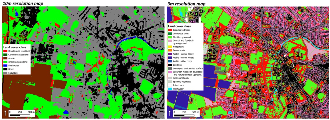
Each pixel on the new map, displayed as a colour shade to reflect a particular type of land cover, represents a three-metre square area – a significant leap from existing products.
Standard land cover maps are 10m resolution, which is enough to identify features such as woodland patches or arable fields but not small individual features on the landscape. For example, existing maps show the City of Westminster has 0.37 km2 of woodland cover but analysis at three-metre resolution has enabled UKCEH scientists to now identify individual trees and calculate that the central London borough has a much higher tree cover of 4.22 km2.
The 3m Land Cover Map brings together an extensive range of data on habitat, vegetation, and agricultural and urban areas in a single, seamless map, so users do not need to acquire, manage and combine several datasets themselves. A major advantage of UKCEH's 3m Land Cover Map is that it will be feasible and cost effective to repeat the exercise in coming years, using satellite-derived data, to enable scientists and land managers to monitor detailed changes in local habitats across England over time.
How to get our maps
Full details are on the UKCEH website. Researchers can access UKCEH’s Land Cover Maps, including the new 3m product, free of charge through EDINA’s Environment Digimap Service if their institution is registered. To discuss access to our maps for other uses, email the UKCEH licensing team at spatialdata@ceh.ac.uk
UKCEH’s Land Cover Map series goes back to 1990 and new products covering Great Britain are now produced annually, available in 10m or 25m raster format or a vector map depicting land parcels with a minimum size of 0.5 hectares. The full suite of Land Cover Map 2025 products, based on satellite data from last year, will be available shortly.
Work on the Land Cover Maps, including the cost of obtaining satellite data, receives National Capability funding awarded to UKCEH from the Natural Environment Research Council. Development of the 3m map was also funded by the AgZero+ project.
– Ends
Media enquiries
For interviews and further information, please contact: Simon Williams, Media Relations Officer, UKCEH. Email simwil@ceh.ac.uk or call +44 (0)7920 295384.
About UKCEH
The UK Centre for Ecology & Hydrology (UKCEH) is a leading independent research institute dedicated to understanding and transforming how we interact with the natural world. With over 600 researchers, we tackle the urgent environmental challenges of our time, such as climate change and biodiversity loss. Our evidence-based insights empower governments, businesses, and communities to make informed decisions, shaping a future where both nature and people thrive.