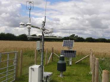
UKCEH has experience in designing, developing and evaluating monitoring and observation sites, programmes and networks, both nationally and internationally. Our expertise in this area encompasses:

  • Assessing stakeholder needs
  • Specifying, procuring and testing instruments
  • Designing, installing and maintaining monitoring stations and networks
  • Ensuring compliance with international monitoring and equipment standards
  • Advancing innovative monitoring sensors and solutions
  • Developing operating protocols, risk assessment and maintenance guidelines.

Case study: Soil moisture monitoring in the UK and India

Soil moisture monitoring station

UKCEH has established COSMOS-UK (Cosmic-ray Soil Moisture Observing System), a long-term network of some 50 soil moisture monitoring sites nationwide.

The network provides near-real-time soil moisture data for use in a variety of applications, including farming, water resources planning, flood forecasting and land-surface modelling. Each site is equipped with an instrument that uses cosmic rays to sense soil moisture over an area of about 12 hectares.

Building on our UK success, we recently collaborated with five leading scientific institutions in India to  create a soil moisture monitoring network there. COSMOS‑India, now operated by our Indian partners, delivers data that help to improve crop productivity and income for farmers, and supports local authorities to plan sustainable water use.

COSMOS-UK website >

COSMOS India website >

Case study: A national evapotranspiration monitoring network for the UK

Evapotranspiration represents the flux of water from the land surface to the atmosphere, and accurate
measurements of this flux are essential for weather prediction and hydrological modelling applications.

UKCEH has developed and continues to grow a national network of eddy covariance stations across the UK, which deliver continuous and long-term observations of evaporation, surface energy balance and carbon fluxes from a range of ecosystems in near-real time.

The network delivers data that can be used for model development and testing, and for estimating the water use efficiency associated with different land management activities. There are 23 systems in operation.

The work was funded by the Natural Environment Research Council through the UK-SCAPE and Soil Security programmes, BEIS, Defra and Natural Resources Wales.