Image
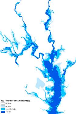
These flood risk maps show an estimate of the areas that would be inundated by floods of the 100-year return period level from non-tidal rivers, in the absence of flood defences. Inundation is given for three flood depth bands (up to 1m, from 1.1m to 2m and over 2m). These flood risk maps have been used by planners, to assess the risk of flooding to proposed developments, and by the insurance industry.
Technical features
- Scale: 50m gridded dataset
- Supply Format: Arc/Info Grid Ascii
- Coverage: Scotland and Northern Ireland
Publications
Morris D G and Flavin R W, 1996. Flood Risk Map for England and Wales (pdf). Institute of Hydrology Report No. 130. 88pp
Obtaining a licence
To obtain a licence, please contact the UKCEH Data Licensing Team by email or telephone, or via our data request form:
Email: spatialdata@ceh.ac.uk