Available translations: English

28.06.2021

The way farmers manage their land has a key role in delivering sustainable agricultural systems. These maintain efficient food production while delivering increased environmental benefits. As part of the ASSIST project, UKCEH has been working to create a series of free tools to support farmers and other land managers in planning and delivering environmental management actions. Collectively called ASSIST E-Tools, they give farmers access to scientific data to help inform their decisions and to monitor and understand the outcomes of these decisions. Dr John Redhead and Dr Tom August explain more…

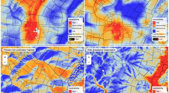
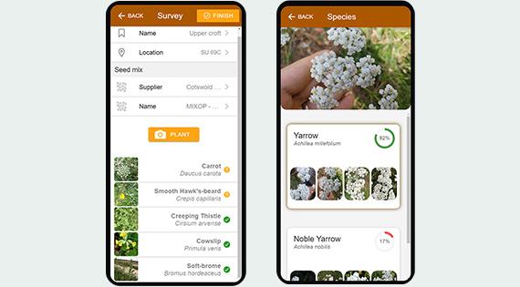
UKCEH has over 25 years’ experience in agri-environmental design, implementation and monitoring, including working with UK farmers and the farming industry to find sustainable solutions that are both supported by scientific evidence and practical for farmers to deliver. We drew on this experience to build the E-tools to ensure they are both useful and user-friendly. E-Planner helps farmers to plan where to put environmental interventions on their farm, E-Surveyor helps farmers to monitor the quality of the habitats they create, and E-Viewer allows farmers and other stakeholders to explore what future farming landscapes might look like.

A farmed landscape in the UK
The way farmers manage their land has a key role in delivering sustainable agricultural systems

In order to manage their land in a sustainable way, farmers have to deliver a range of environmental benefits (e.g. clean water, wildlife habitats) as well as continuing to produce sufficient, high quality food. This can be a difficult balancing act. Farmers have always needed a good understanding of ‘what works well where’ in terms of growing crops. And, in recent years, farmers have had access to an increasing amount of high-resolution data on the health and productivity of their crops and livestock on which to base agronomic decisions and monitor their outcomes. However, the equivalent data and tools on the environmental aspects of farming have previously been difficult to come by.

E-Planner: enhancing farm environmental decisions

E-Planner is a free, web-based app to help farmers plan environmental management decisions using detailed maps similar to those produced from precisions agricultural data. E-Planner is designed to  make it easy for you to identify what environmental options might be best suited to a given area, or which areas might be best for a particular option. We designed E-Planner based on feedback from farmers, farm advisers and agronomists to keep it simple, easy-to-use and easy-to-interpret.

E-Planner is based on high resolution data on topography, soils, flood risk, habitats and landscape features. We then used our experience and science to identify how each variable affects the suitability of land for a set of environmental outcomes – what factors make it easier for farmers to manage the land for that outcome, make it more likely for the management to achieve its goals and less likely to have any unintended consequences? E-Planner uses this to combine the environmental data into ‘heat maps’ of overall suitability for five different groups of environmental management actions (e.g. AES options), which we call ‘environmental opportunities’:

Environmental opportunity

Example management actions

Flower-rich pollinator habitat

Sowing annual pollen/nectar producing plants

Establishing perennial wildflower areas

Restoration of species-rich grassland

Sown winter bird food

Sow seed-bearing plants

Supplementary feeding

Water resource protection

Grass buffer strips

Cover crops

Water storage features

Wet grassland restoration

Establishing hay cutting and grazing regimes

Managing drainage

Reseeding of suitable wildflowers

Woodland creation

Planting of native trees on-farm

Protection of existing trees

Using E-Planner starts with you selecting your area of interest from anywhere in GB. It then loads the suitability maps, and allows you to explore them. Using E-Planner speeds up the process of narrowing down which options and areas to investigate in more detail. The tool also provides a ‘Next Steps’ page, with links to practical guidance on how to implement environmental management actions.

Image
Four screenshots from E-Planner

E-Planner is free to use and available at
assist-e-planner.ceh.ac.uk

E-Surveyor: supporting habitat monitoring

Once farmers have created a wildlife habitat, it’s important for them to be able to understand how well it’s delivering. Farmers are experts in understanding how well their crops and livestock are doing, but it can be harder to identify the performance of a seed mix for wildlife, or what wildlife it might be supporting. Our new, free mobile app, E-Surveyor, enables farmers to assess, simply and easily, the quality of wildlife habitats on their farm and learn more about the biodiversity these habitats support.

E-Surveyor uses artificial intelligence to automatically and rapidly identify thousands of plant species from photographs taken on a mobile phone. The app can help to identify a single flower that you don’t recognise, or identify all the flowers found in your wildlife habitat. The latter will generate a report on how successful the seed mix has been - how many of the sown species have grown and are there any other species? The app also tells you what wildlife is supported by the plant species you have grown (e.g. insect pollinators) and show you how well your success compares to other farmers.

Image
Screens from E-Surveyor

E-Surveyor enables farmers to assess wildlife habitats on their land

 
E-Surveyor is currently being tested prior to general release – you can see a preview video here or keep an eye out for release of the app here.

E-Viewer: exploring future landscapes

Achieving sustainable agricultural systems is a complex process. It operates over many spatial scales, from landscapes to farms to fields and involves people from across the farming industry, the food supply chain, the academic research community and the wider public who live in the UK’s agricultural landscapes.

Therefore, being able to understand potential ideas and plans for the future, and explore how new agricultural systems might look and feel is key. The E-Viewer helps us do just that. It is a new system that uses a gaming engine to create realistic, immersive visualisations of potential future landscapes. Imagine seeing how your farm might look if you implemented some of the management actions that E-Planner suggested? You could explore the aesthetic and biodiversity impacts of adding new habitats for example. Or it could be larger-scale changes in the amount of woodland, grassland or the type of crops in our landscapes.

E-Viewer can help us work together and understand one another’s preferences, to give us the best chance of achieving sustainable agriculture in the UK.

E-Viewer is a framework we're currently developing for use alongside the other E-Tools.

Contact

My research focuses on exploring how we can use land in a way that is sustainable, in terms of both protecting nature and ensuring human benefits.
My work focuses on bridging the gap between research scientists and information technology experts.