Available translations: English

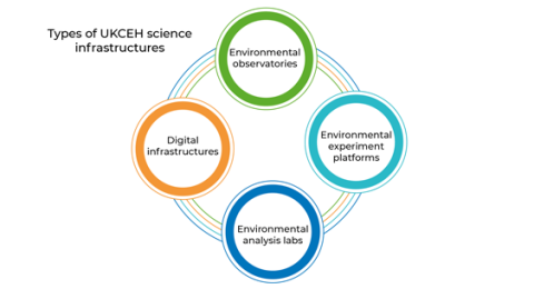
UKCEH operates four classes of science infrastructure:

Image
UKCEH types of science infrastructures


Class 1: Environmental observatories 

Purpose

To observe and measure UK environmental processes, status and change – within and across UK geographies, habitats and land uses.

Why do they matter?

Observation and measurement is important to track environmental processes, interconnection, status and change, where change is occurring at unprecedented scale and speed due to human actions.  This observation needs to be UK-wide in coverage and sustained over time: to capture the complexity and variability of geology, weather, habitats and land uses that drive biogeochemical-ecological-hydrological interactions and biodiversity from local to national scales.  

What are they?

  1. Instrumented sites: Instrumented sites and networks of sites for in-situ, structured, frequent or near-continuous environmental measurement and sampling (often automated).
  2. Periodic surveys: Structured professional survey, measurement and sampling of multiple sites, repeated at intervals (usually several years).
  3. Wildlife monitoring schemes: Structured and unstructured national survey (including opportunistic sightings) of wildlife species, invasive species, biodiversity, pollution and disease – conducted by professional and volunteer (citizen) scientists, NGOs, societies, recording schemes.
  4. Discovery collections and archives: Physical environmental samples and specimens from known dates and locations which can be re-analysed to yield new information about environmental status and change over time (e.g. when new questions or analytical technologies emerge).
  5. Mobile observing platforms: Underpinning capability, such as portable or mobile equipment, that enables environmental survey, observation, imaging and mapping at selected places and scales.

Class 2: Environmental experiment platforms 

Purpose

To conduct controlled or semi-controlled experiments to understand environmental processes, change, causes and effects.

Why do they matter?

Platforms for controlled experiments allow us to simulate and manipulate real environments: 
-    To disentangle, understand and model underlying environmental processes, causes and effects
-    To develop, test and validate the effectiveness and consequences of environmental management interventions and solutions

What are they? 

  1. Controlled environment platforms (micro- or mesocosms): Wholly or partly enclosed facilities constructed to allow environmental variables (such as atmospheric composition) to be precisely controlled and manipulated, and environmental effects to be closely monitored.
  2. Field research platforms (macrocosms): Open field sites, catchments or farms equipped as outdoor 'Living Laboratories': (a) to experimentally manipulate and monitor the environment; and/or (b) to develop and test innovative environmental management regimes.

Class 3: Environmental analysis labs 

Purpose

To analyse environmental samples to determine their biological, chemical and physical properties, including taxonomic identity.

Why do they matter?

Analytical laboratories and test facilities provide underpinning capability to support both observation and experiment (see above).  

What are they?

  1. Analysis labs: Equipped to analyse environmental samples to determine their biological, chemical and physical properties, including taxonomic identity and ecological function.
  2. Test labs: Used to prepare samples and calibrate equipment for environmental measurement and analysis.

Class 4: Digital infrastructures  

Purpose

To harness data, modelling and digital technology for environmental observation, research, data analytics, simulation, forecasting, scenario-testing and solutions.

Why do they matter?

Sophisticated digital technology capabilities are necessary to enable environmental observation, experiment and analysis (see asset classes 1, 2 and 3) and then to harness the resulting data for environmental simulation, forecasting and scenario-testing. UKCEH’s digital technology infrastructure comprises a mix of physical assets (hardware, networks) and digital assets (software, data) linked via communications technology. To enable whole-system and collaborative environmental science these digital assets are increasingly integrated and FAIR: Findable; Accessible; Interoperable; Re-usable.

Category descriptions

  1. Environmental data and information: UKCEH provides stewardship, quality assurance and access to environmental data and information products used for research, public, policy and business applications. Raw data are derived directly from environmental observations and experiments, by professional and citizen scientists, and made available via publicly accessible data centres. Raw data from different sources are then collated, combined, analysed, interpreted and visualised – often using models – to create value-added information products and services. UKCEH information products and services are available to users in different forms: some via data centres; some via digital tools, including mobile apps.
  2.  Environmental models: Digital code in the form of models, representations or tools used to understand, visualize and predict environmental (land-water-air) processes and behaviour. Models may be process-based, statistical or agent-based (behavioural). They are continually tested and improved using real-world data from observations and experiments. Environmental models are widely used: (i) by researchers to test and improve our fundamental environmental understanding; and (ii) by policy-makers and businesses to develop practical tools for environmental forecasting, scenario-analysis, decision-making and performance reporting. Data and information products used and generated by environmental models are included in Category 1 above.


This category includes UKCEH models (wholly or largely owned, created and developed by UKCEH) and community models (hosted, led, operated and co-developed by UKCEH with and for the wider research community). Environmental models in this category typically display the following characteristics:

  • Digital model code is increasingly shared, open-source, published, peer-reviewed, interoperable, re-usable.
  • Models developed through substantial investment (team approach; person-years of effort; £Ms).
  • Models may combine multiple environmental, economic, social variables in a whole-system approach.
  • Models may include ‘hindcasting’ (re-analysis of past), ‘nowcasting’ (near real-time simulation), forecasting (predicting future status and change).
  • Digital models or representations of the environment may also be known as ‘simulators’, ‘emulators’, ‘digital twins’, ‘virtual environments’  


3.    Data analytics, methods and approaches: Used to capture, combine, interrogate, analyse and interpret environmental data. Such methods and approaches are ideally interoperable and re-usable, and may include, for example: artificial intelligence and machine learning; ‘big data’ science and informatics.

4.    Software infrastructure: Used to underpin and enable the above categories. For example UKCEH ‘Virtual Labs’ which provide a shared digital workspace for collaborative data analytics and modelling; re-usable middleware for developing apps, tools and data portals; mobile apps and portals that enable data input and data visualisation.

5.    Digital computing platforms: Scientific computing capability to underpin and enable the above categories (above and beyond standard workplace IT provision). Includes physical assets such as computer hardware and virtual assets such as cloud service, both of which provide computing and storage platforms. Digital computing provision may be owned and operated by UKCEH or by external service providers.

Back to Science Infrastructure menu