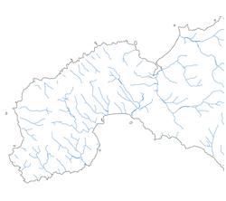
The UKCEH Digital River Network of Great Britain, historically referred to as the Watercourses Network, was derived from Ordnance Survey 1:50,000 maps and was the first continuous digital river network to be produced for Great Britain. There are no breaks in line work where rivers are crossed by bridges or pass through tunnels and this is a major advantage if the dataset is to be used for modelling.
The dataset has been used to define flow paths in UKCEH’s Integrated Hydrological Digital Terrain Model (IHDTM), which in turn is used to define drainage paths in the FEH (Flood Estimation Handbook) Web Service. Its hydrological consistency is important for modelling purposes, avoiding issues which can occur where river network datasets have been created independently of a complimentary digital terrain model e.g. rivers are shown to flow up hills or otherwise against DTM flow directions.
The network has been used to define flow paths in UKCEH’s Integrated Hydrological Digital Terrain Model (IHDTM), which in turn is used to define drainage paths in the Flood Estimation Handbook CD-ROM.
Technical features
- Scale: 1:50,000
- Supply Format: Shape file
- Coverage: GB
Publications
Moore R V, Morris D G and Flavin R W, 1994. Sub-set of UK digital 1:50,000 scale river centreline network. NERC, Institute of Hydrology, Wallingford.
Obtaining a licence
UKCEH provides a Web Mapping Service for 1:50,000 digital river network data. Using our map viewer, high-resolution data for the whole of Great Britain can be seen, but not downloaded. Images of the 1:50,000 digital river network can be captured. If these are published, the data must be acknowledged appropriately.
For information on obtaining a licence, please contact the UKCEH Data Licensing Team:
Email: spatialdata@ceh.ac.uk
Further information on this dataset can be found on the Environmental Information Platform.
Academic research and education
The UKCEH Digital River Network of Great Britain (1:50,000) data are available for free for users of the EDINA Environment Digimap service, which includes staff and students at more than a hundred UK further and higher education establishments.