Scientific challenge
Climate change will increase temperatures and change rainfall across England, Wales and Scotland. In turn, this will modify patterns of river flow and groundwater recharge, affecting the availability of water and changing the aquatic environment. There have been many studies of the impact of climate change on river flows in different parts of the UK, but coverage is uneven and methods vary. This means it is difficult to compare different locations and so identify appropriate adaptation responses.
Project overview
The Future Flows and Groundwater Levels (FFGWL) project addressed these issues by carrying out for the first time a consistent assessment of the impact of climate change on river flows and groundwater levels across England, Wales and Scotland. It used the latest projections from the UK Climate Impact Programme, including the UKCP09 probabilistic climate projections from the Met Office Hadley Centre.
FFGWL developed two unique datasets for Great Britain:
- Future Flows Climate (FF-HadRM3-PPE), an 11-member ensemble 1km gridded projection time series (1950-2098) of precipitation and potential evapotranspiration for Great Britain, developed for hydrological and hydrogeological application based on HadRM3-PPE run under the Medium emission scenario SRES A1B.
- Future Flows Hydrology (FF-HydMod-PPE), an 11-member ensemble projection of daily river flow and monthly groundwater levels time series (1951-2098) for 282 rivers and 24 boreholes in Great Britain.
They represent a nationally consistent ensemble of 11 plausible realisations (all equally likely) of almost 150 years of climate, river flow and groundwater regime, and enable us to investigate the role of climate variability on river flow and groundwater levels nationally and how this may change in the future. Considering all ensemble members together accounts for some climate change uncertainty.
The Future Flows Project was a partnership project co-funded by the Environment Agency of England and Wales, Defra, UK Water Industry Research, the Centre for Ecology & Hydrology, the British Geological Survey and Wallingford Hydrosolutions. The project ran between March 2010 and Spring 2012.
Products and datasets
Four FFGWL products are available under specific licensing conditions:
- Future Flows Climate (FF-HadRM3-PPE):
Gridded transient projections of precipitation (APr) and potential evapotranspiration (PE) over Great Britain for 1950-2098 at a fine spatial resolution for hydrological and groundwater modelling. They can be used to generate new river flow or groundwater level time series for any catchment in Great Britain. - Future Flows Hydrology (FF-HydMod-PPE):
River flow and groundwater level transient projections for the project's 282 river catchments and 24 boreholes for 1951-2098, derived from Future Flows Climate using the models HydMod. For each project site they provide an ensemble of plausible realisations of the river flow and groundwater level regime under the SRES A1B emission scenario, including climate change signal and climate variability. - FF-HadRM3-PPE-CatID:
Catchment average daily climate transient projections for the project's 282 river catchments and 24 boreholes for 1950-2098, derived from Future Flows Climate. They can be used as input of any lumped impact model needing precipitation and PE climate input for the project catchments. - FF-HydMod-RegionID-2050:
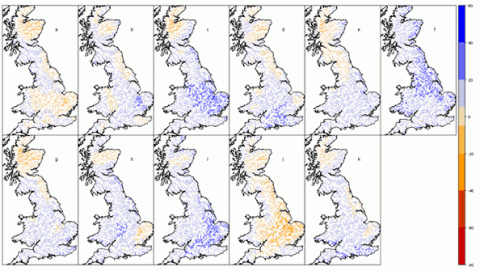
National and recharge time-slice changes in river flow / groundwater levels which summarise the possible signals of change as "snapshot" maps. For some selected sites, this includes probabilistic time-slice change based on UKCP09-sample. Example:

Image: Map of percentage changes in winter (DJF) mean river flow for the 2050s as simulated by the hydrological model CERF with each of the Future Flows Climate members using the SRES A1B emission scenarios: from top left - a HadRM3Q0 (unperturbed, run afgcx); b HadRM3Q3 (run afixa); c HadRM3Q4 (run afixc); d HadRM3Q6 (run afixh); e HadRM3Q9 (run afixi); f HadRM3Q8 (run afixj); g HadRM3Q10 (run afixk); h HadRM3Q14 (run afixl); i HadRM3Q11 (run afixm); j HadRM3Q13 (run afixo); k HadRM3Q16 (run afixq)
- More information and downloads are available in Future Flows maps and datasets. The products are available free of charge for non-commercial use only under licence agreements.
Uses
Possible uses for FFGWL products and datasets include:
- Climate change adaptation policy: by developing an understanding of the rate of change of river flows, policymakers can consider the implications for areas such as abstraction licensing and discharge consents, and adapt policy accordingly.
- Studies of the impact of climate change on water availability: water companies will be able to evaluate the impact of climate change consistently, thereby improving future planning.
- River basin management: understanding changes in flow will allow river basin management plans to be tested for robustness.
- Evaluating the impact of climate change on aquatic ecology: many aquatic species are dependent on flows but poor availability of data has limited consistent assessment of possible changes.
Projections
FFGWL used the latest climate change projections available from the UKCIP for UK climate change impact assessment. In particular, it exploited the following UKCP09 products to assess changes in river flows and groundwater levels across England, Scotland and Wales.
- Projections from the ensemble of 11 variants of the Met Office Regional Climate Model (HadRM3-PPE) as continuous time series of climate variables from 1950 to 2099.
- Probabilistic projections of changes in climate variables as an ensemble of 10,000 monthly change factors for the following three time-slice and green-house gas emission scenario combinations:
- 2050s and medium emissions scenario (A1B)
- 2080s under a medium emissions scenario (A1B)
- 2050s under a high emissions scenario (A1F1)
Bias correction and downscaling
Climate projections generated from Global or Regional Climate Models (RCM) are not suitable for direct use in hydrological models because of differences in scale between modelled atmospheric processes and hydrological processes. Based on the latest scientific knowledge of how to exploit RCM outputs in hydrology, a bias-correction and downscaling procedure was implemented over Britain to generate Future Flows Climate.
Hydrological modelling
The range of river sites for which FFGWL has generated transient projections necessitated the use of different hydrological and groundwater models. FFGWL uses three types of hydrological and groundwater models:
- Regionalised models (CERF, ZOOM), where a range of catchments (from the whole of Great Britain for the hydrological model, for an aquifer region for the groundwater model) are considered together and the best overall set of parameters (sometimes linked to land use and soil characteristics) are defined.
- Catchment models (PDM, R-Groundwater), where the model parameters are fine-tuned to best reproduce the site gauged flow statistics.
- Hybrid model (CLASSIC), where a combination of regionalised and calibrated parameters are used.
The advantage of the regionalised parameter model is that it extends the climate range under which the model parameters are evaluated; this is particularly important in a warming climate for catchments where it is possible that evaporation processes might be water-limited. The advantage of catchment calibrated models is that they are designed to reproduce the best local hydrological processes.
Locations
To capture the range of climate, land use, geological and geographical characteristics found in England, Wales and Scotland, the project modelled a total of 282 river catchments and 24 boreholes. For details of the sites involved and the data, please see the future flows hydrology station list for April 2012 (PDF, 1.13mb). The sites were chosen because they had good records and the hydrological processes could be well reproduced by conceptual hydrological or groundwater level models.
